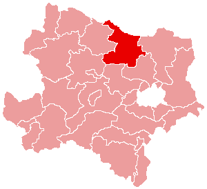
- District de hollabrunn
-
District de Hollabrunn
Hollabrunn 
Informations Pays  Autriche
Land  Basse-Autriche
Centre administratif Hollabrunn Superficie 1 010,72 km² Population 50 070 hab (15 mai 2001) Densité 50 hab/km² Immatriculation HL Le district de Hollabrunn est une subdivision territoriale du Land de Basse-Autriche en Autriche. Il est limitrophe au Nord de la République tchèque. En 1890, la population du district s’élevait à 77.584 habitants, atteignant ainsi son niveau maximum. Depuis, la population est en diminution constante. Actuellement, selon les résultat du recensement de « Statistik Austria » de 2001, on dénombre 50.070 résidants dans le district.
Sommaire
Géographie
Relief
Lieux administratifs voisins
Économie et infrastructures
Communes
Le district de Hollabrunn est subdivisé en 24 communes :
- Alberndorf im Pulkautal
- Göllersdorf
- Grabern
- Guntersdorf
- Hadres
- Hardegg
- Haugsdorf
- Heldenberg
- Hohenwarth-Mühlbach am Manhartsberg
- Hollabrunn
- Mailberg
- Maissau
- Nappersdorf-Kammersdorf
- Pernersdorf
- Pulkau
- Ravelsbach
- Retz
- Retzbach
- Schrattenthal
- Seefeld-Kadolz
- Sitzendorf an der Schmida
- Wullersdorf
- Zellerndorf
- Ziersdorf
- Portail de l’Autriche
Catégories : District d'Autriche | Basse-Autriche
Wikimedia Foundation. 2010.


