Devil's Beef Tub
Contenu soumis à la licence CC-BY-SA. Source : Article Devil's Beef Tub de Wikipédia en français (auteurs)
Regardez d'autres dictionnaires:
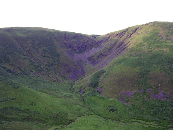
Devil's Beef Tub — The Devil s Beef Tub. The Devil s Beef Tub is a deep, dramatic hollow in the hills north of the Scottish town of Moffat. The 500 foot (150 m) deep hollow is formed by four hills, Great Hill (1527 ft, 465 m), Peat Knowe, Annanhead… … Wikipedia
Moffat Hills — The Moffat hills[1] are a range of hills in the Southern Uplands of Scotland. They form a distinctly triangular shape with a west facing side, a north facing side, and a south east facing side. It is 17 kilometres from east to west across this… … Wikipedia
Dumfries and Galloway — See also: Dumfries and Galloway (UK Parliament constituency) Dumfries and Galloway Dumfries an Gallowa Dùn Phris is Gall Ghaidhealaibh Logo Location … Wikipedia
Moffat — For other uses, see Moffat (disambiguation). Coordinates: 55°19′55″N 3°26′31″W / 55.332°N 3.442°W / 55.332; 3.442 … Wikipedia
Moffat — es un antiguo burgh y una localidad balneario en Dumfries and Galloway, Escocia, situada junto al río Annan, con una población de alrededor de 2500 habitantes. El edificio más insigne de la ciudad es el Moffat House Hotel, diseñado por John Adam … Wikipedia Español
River Clyde — This article is about the river which flows through Glasgow. For other rivers, see Clyde River (disambiguation). For the ship, see SS River Clyde. Coordinates: 55°40′0″N 5°0′0″W / 5 … Wikipedia
Dumfries — For other uses, see Dumfries (disambiguation). Coordinates: 55°04′12″N 3°36′11″W / 55.070°N 3.603°W / 55.070; 3.603 … Wikipedia
Dumfriesshire — Not to be confused with Dumfriesshire (Scottish Parliament constituency) or Dumfriesshire (UK Parliament constituency). Dumfries County (until circa 1890) … Wikipedia
River Annan — The River Annan ( Uisge Annan in Gaelic) is a river in southwest Scotland. It rises at the foot of Hart Fell, five miles north of Moffat. A second fork rises on Annanhead Hill and flows through the Devil s Beef Tub before joining at the Hart Fell … Wikipedia
Southern Uplands — The Southern Uplands is the southernmost of Scotland s three major geographic areas (the others being the Central Belt and the Highlands). They lie South of the Southern Uplands fault line that runs from Girvan on the Ayrshire coast in the West… … Wikipedia