Derwonaji
Contenu soumis à la licence CC-BY-SA. Source : Article Derwonaji de Wikipédia en français (auteurs)
Regardez d'autres dictionnaires:
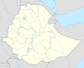
Derwonaji — (also transliterated Derwernache) is a town in eastern Ethiopia. Located in the Jijiga Zone of the Somali Region, this town has a longitude and latitude of 9°50′N 43°02′E / 9.833°N 43.033°E … Wikipedia
Derwonaji — 9.833333333333343.033333333333 Koordinaten: 9° 50′ N, 43° 2′ O … Deutsch Wikipedia
Awbere — 9.633333333333343.233333333333 Koordinaten: 9° 38′ N, 43° 14′ O … Deutsch Wikipedia
Jijiga-Zone — Die Jijiga Zone ist eine Verwaltungszone der Somali Region in Äthiopien. Laut Volkszählung von 2007 hatte sie 966.213 Einwohner, von denen 20,04 % (203.263) in städtischen Gebieten lebten.[1] Hauptstadt der Zone ist Jijiga (Dschidschiga),… … Deutsch Wikipedia
Jijiga Zone — Jijiga is one of nine zones of the Ethiopian Somali Region. This zone is named after its largest city, Jijiga. Other towns and cities in this zone include Awbere, Derwonaji and Hart Sheik. Jijiga is bordered on the south by Degehabur, on the west … Wikipedia
Awbere (woreda) — Awbere is one of the 47 woredas in the Somali Region of Ethiopia. Part of the Jijiga Zone, Awbere is bordered on the southwest by Jijiga, on the west and north by the Shinile Zone, on the east by Somalia, and on the southeast by Kebri Beyah.… … Wikipedia
Somali (Region) — Somali Symbole … Deutsch Wikipedia
Daror — 8.216666666666744.7 Koordinaten: 8° 13′ N, 44° 42′ O … Deutsch Wikipedia
Kebri Beyah — 9.143.166666666667 Koordinaten: 9° 6′ N, 43° 10′ O … Deutsch Wikipedia

 Éthiopie
