Cité de Stirling
- Cité de Stirling
-
31° 53′ 00″ S 115° 48′ 00″ E / -31.8833, 115.8
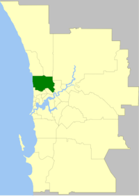
La Cité de Stirling (City of Stirling en anglais) est une zone d'administration locale dans la banlieue de Perth en Australie-Occidentale en Australie à environ 10 kilomètres au nord du centre ville. C'est la zone d'administration locale la plus peuplée de l'État.
La zone est divisée en un certain nombre de localités:
- Balcatta
- Balga
- Carine
- Churchlands
- Coolbinia
- Dianella
- Doubleview
- Glendalough
- Gwelup
- Hamersley
- Herdsman
- Inglewood
- Innaloo
- Joondanna
- Karrinyup
|
- Menora
- Mirrabooka
- Mount Lawley
- Nollamara
- North Beach
- Osborne Park
- Scarborough
- Stirling
- Trigg
- Tuart Hill
- Waterman
- Wembley Downs
- Westminster
- Woodlands
- Yokine
|
La zone a 14 conseillers et est découpée en 7 circonscriptions qui élisent chacune 2 conseillers:
- Balga Ward
- Coastal Ward
- Doubleview Ward
- Hamersley Ward
- Inglewood Ward
- Lawley Ward
- Osborne Ward
Lien externe
Catégorie :
- Zone d'administration locale de Perth
Wikimedia Foundation.
2010.
Contenu soumis à la licence CC-BY-SA. Source : Article Cité de Stirling de Wikipédia en français (auteurs)
Regardez d'autres dictionnaires:
Stirling Iron Works — Stirling Iron WorksThe Stirling Iron Works owned by Peter Townsend was one of the first steel and iron manufacturer in the American colonies and the first steel producer in the colony of New York. The company was most famous for forging the… … Wikipedia
Stirling railway station, Perth — Stirling Train Station is a Transperth train station 9km from Perth Train Station, in Western Australia. It is on the Joondalup Line.HistoryConstructed from 1990 to 1992, it was built as part of the Northern Suburbs Transit System and the… … Wikipedia
Cite de Londres — Cité de Londres Cité de Londres Géographie Statut London borough, Cité Superficie Total Rang: 2,9 km² Démographie Population … Wikipédia en Français
Cité De Londres — Géographie Statut London borough, Cité Superficie Total Rang: 2,9 km² Démographie Population … Wikipédia en Français
Cité de Londres — Carte de localisation du district dans le Grand Londres … Wikipédia en Français
Cité de londres — Géographie Statut London borough, Cité Superficie Total Rang: 2,9 km² Démographie Population … Wikipédia en Français
Stirling, Alberta — Infobox Settlement official name = Village of Stirling other name = native name = nickname = THE JUNCTION TOWN (1912) [Lethbridge Herald [Archives http://lethbridgeherald.newspaperarchive.com/PdfViewer.aspx? ] settlement type = Village motto =… … Wikipedia
Stirling — infobox UK place country = Scotland official name= Stirling gaelic name= Sruighlea scots name= Stirlin population= 41,243 (2001 Census) os grid reference= NS795935 unitary scotland= Stirling lieutenancy scotland= Stirling and Falkirk constituency … Wikipedia
Stirling, Western Australia — Infobox Australian Place | type = suburb name = Stirling city = Perth state = wa caption = lga = City of Stirling area = 4.6 postcode = 6021 pop = 7,034 (2006 census) dist1 = 10 | dir1 = NNW | location1=Perth est = 1960s fedgov = Stirling… … Wikipedia
Stirling Moss — Infobox F1 driver Name = Stirling Moss Caption = Moss in 2008 Nationality = flagicon|UK British Years = 1951 1961 Team(s) = Mercedes Benz, Maserati, Vanwall, Rob Walker Cooper Lotus Races = 67 (66 starts) Championships = 0 Wins = 16 Podiums = 24… … Wikipedia
 Australie
