Cité de Joondalup
- Cité de Joondalup
-
31° 44′ 00″ S 115° 46′ 01″ E / -31.7333, 115.767
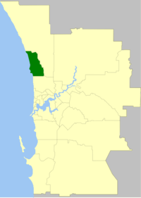
La Cité de Joondalup (City of Joondalup en anglais) est une zone d'administration locale dans la banlieue de Perth en Australie-Occidentale en Australie à environ 25 kilomètres au nord du centre ville.
La zone est divisée en un certain nombre de localités :
- Beldon
- Burns Beach
- Connolly
- Craigie
- Currambine
- Duncraig
- Edgewater
- Greenwood
- Heathridge
- Hillarys
- Iluka
- Joondalup
- Kallaroo
- Kingsley
- Kinross
- Marmion
- Mullaloo
- Ocean Reef
- Padbury
- Sorrento
- Warwick
- Woodvale
La zone a douze conseillers et est découpée en six circonscriptions.
Catégories :
- Zone d'administration locale de Perth
- Fondation en 1998
Wikimedia Foundation.
2010.
Contenu soumis à la licence CC-BY-SA. Source : Article Cité de Joondalup de Wikipédia en français (auteurs)
Regardez d'autres dictionnaires:
Joondalup, Western Australia — Infobox Australian Place | type = suburb name = Joondalup city = Perth state = wa caption = The city north area of Joondalup at night lga = City of Joondalup area = 11.8 postcode = 6027 pop = 8,420 (2006 census)Census 2006… … Wikipedia
Ville de Joondalup — Cité de Joondalup Cité de Joondalup Géographie État : Australie Occidentale Région : Perth … Wikipédia en Français
Joondalup railway line, Perth — The Joondalup Line, (incorrectly known as Currambine Line or Clarkson Line), is a suburban railway line in Perth, Australia. It runs through Perth’s northern suburbs, mostly traversing the median strip of the Mitchell Freeway, and connects… … Wikipedia
Lakeside Joondalup Shopping City — infobox shopping mall shopping mall name = Lakeside Joondalup Shopping City image width = caption = location = Joondalup, Western Australia, Australia opening date = November 1994 owner= ING Real Estate manager= Savills WA Pty Ltd developer= ING… … Wikipedia
Zones d'administration locale d'Australie-Occidentale — Les zones d administration locales d Australie Occidentale Il y a 141 zones d administration locale en Australie Occidentale si l on tient compte des deux comtés que sont le comté de l île Christmas et le comté des îles Cocos. Les fonctions de… … Wikipédia en Français
Contenu:Australie — Projet:Australie/Liste des articles Liste mise à jour régulièrement par MyBot (d · c · b) à partir des articles liés au bandeau {{Portail Australie}} Modifications récentes des articles ayant le bandeau de ce portail… … Wikipédia en Français
Circonscription de Moore — 31° 44′ 20″ S 115° 45′ 29″ E / 31.739, 115.758 … Wikipédia en Français
Mandurah railway line, Perth — The Mandurah Railway Line is an interurban railway line, running through the south western suburbs of Perth, Western Australia. Partly located in the median of the Kwinana Freeway, the line connects Perth with Western Australia s second largest… … Wikipedia
SmartRider — is Transperth s contactless electronic ticketing system using smartcard technology for the process of charging patrons for public transport. The SmartRider is a credit card sized smartcard incorporating a microchip and internal aerial, allowing… … Wikipedia
Transperth Trains — Infobox Public transit name = Transperth Trains imagesize = 200px imagesize2 = 300px locale = Perth, Western Australia transit type = Rapid transit Commuter rail began operation = lines = 6 (173.1km) stations = 69 ridership = 175,000 track gauge … Wikipedia
 Australie
