Cité de Canning
- Cité de Canning
-
32° 01′ 00″ S 115° 55′ 59″ E / -32.0167, 115.933
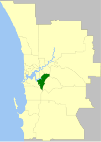
La Cité de Canning (City of Canning en anglais) est une zone d'administration locale dans la banlieue de Perth en Australie-Occidentale en Australie à environ 10 kilomètres au sud-est du centre ville.
La zone est divisée en un certain nombre de localités:
- Bentley
- Canning Vale
- Cannington
- East Cannington
- Ferndale
- Leeming
- Lynwood
- Parkwood
- Queens Park
- Riverton
- Rossmoyne
- Shelley
- St James
- Welshpool
- Willetton
- Wilson
La zone a 9 conseillers et est découpée en 3 circonscriptions.
Lien externe
Catégories :
- Zone d'administration locale de Perth
- Fondation en 1978
Wikimedia Foundation.
2010.
Contenu soumis à la licence CC-BY-SA. Source : Article Cité de Canning de Wikipédia en français (auteurs)
Regardez d'autres dictionnaires:
Canning Bridge — is a traffic bridge which is the most downstream crossing of the Canning River in the city of Perth, Western Australia. The bridge is a part of Canning Highway, and it connects the suburbs of Como and Applecross. The Canning River is… … Wikipedia
Canning, South 24 Parganas — Infobox Indian Jurisdiction native name = Canning | type = city | latd = 22.32 | longd = 88.67 locator position = right | state name = West Bengal district = South 24 Parganas leader title = leader name = altitude = 4 population as of = 2001… … Wikipedia
Ville de Canning — Cité de Canning Cité de Canning Géographie État : Australie Occidentale Région : Perth … Wikipédia en Français
Canning Highway — Infobox Australian Road road name = Canning Highway route route route photo = Canning Bridge 2006 SMC.jpg caption = Canning Bridge length = 17 direction = Northeast Southwest start = finish = Queen Victoria Street, Fremantle, Perth est = 1920s… … Wikipedia
Cité de Gosnells — 32° 04′ 00″ S 115° 58′ 59″ E / 32.0667, 115.983 … Wikipédia en Français
Joe Canning — Infobox GAA player code= Hurling sport = Hurling name = Joe Canning irish = Seosamh Ó Cainín fullname = Joseph Canning placeofbirth = Portumna countryofbirth = County Galway dob = height = 6 2 nickname = Joey county = Galway province = Connacht… … Wikipedia
Fort Canning Tunnel — (zh cp|c=福康宁遂道|p=Fúkāngníng Suìdào), abbreviated as FCT,cite web|url=http://www.worldroads2006.com/technical.htm|title=World Roads Conference 2006 Technical Tours|accessdate=2006 11 25|year=2005|work=World Roads Conference 2006|publisher=Land… … Wikipedia
Affaire Elizabeth Canning — Portrait monochrome d Elizabeth Canning en robe vers 1820. Elizabeth Canning, née le 17 septembre 1734 et décédée en juin 1773, est une servante anglaise, qui fut au centre d une affaire judiciaire qui compte parmi les plus célèbres débats… … Wikipédia en Français
Fort Canning Lighthouse — Infobox lighthouse|name=Fort Canning Lighthouse location=Fort Canning Hill, Singapore image size=150px caption= coordinates = yearlit=1903 yeardeactivated=1958 automated=No intensity=White and Red 20,000 cd elevation=36.3 metres range=18 nautical … Wikipedia
Circonscription de Canning — 32° 38′ 02″ S 116° 06′ 47″ E / 32.634, 116.113 … Wikipédia en Français
 Australie
