Castle Combe
Contenu soumis à la licence CC-BY-SA. Source : Article Castle Combe de Wikipédia en français (auteurs)
Regardez d'autres dictionnaires:
Castle Combe — is a small village in Wiltshire, England, with a population of about 350. It is renowned for its attractiveness and tranquillity, and for fine buildings including the medieval church. The fourteenth century Market Cross, erected when the… … Wikipedia
Castle Combe — 51.495277777778 2.2241666666667 … Deutsch Wikipedia
Castle Combe Castle — stood to the north of the village of Castle Combe, Wiltshire, England. (gbmapping|ST837777).It was a medieval motte and bailey castle standing on a limestone spur. It was unusual in that it had a keep with at least four and possibly five baileys … Wikipedia
Castle Combe Circuit — Motorsport venue Name = Castle Combe Circuit | Location = Wiltshire, England Events = Formula Ford Length km = 2.977 Length mi = 1.85 Turns = 7 Record time = 0:59.387 Record driver= Dan Clarke Record team = Räikkönen Robertson Racing Record class … Wikipedia
Combe Mill — is a sawmill situated adjacent to the River Evenlode (at grid reference SP417150) close to Combe railway station, between the villages of Combe and Long Hanborough in Oxfordshire, England. Originally powered by a waterwheel, there is now a beam… … Wikipedia
Combe Delafield and Co. — Combe Delafield and Co. was an English brewery, which during the nineteenth century was one of the major brewers in London, before being acquired by Watney in 1898, thus forming Watney Combe and Reid.HistoryThe Woodyard Brewery, of Castle Street … Wikipedia
Combe Haven — Site of Special Scientific Interest … Wikipedia
Combe Martin — Coordinates: 51°11′N 4°01′W / 51.19°N 4.02°W / 51.19; 04.02 … Wikipedia
Combe St Nicholas — Coordinates: 50°53′45″N 2°59′37″W / 50.8957°N 2.9936°W / 50.8957; 2.9936 … Wikipedia
Harptree Combe — Infobox SSSI name=Harptree Combe aos=Avon interest=Biological gridref=gbmappingsmall|ST561558 area=13.1 hectares (32.3 acres) notifydate=1954 http://www.natureonthemap.org.uk/map.aspx? ] Harptree Combe (gbmapping|ST561558) is a 13.071 hectare (32 … Wikipedia
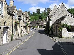 La rue principale avec la croix du marché au bout.
