Buchanan Highway
- Buchanan Highway
-
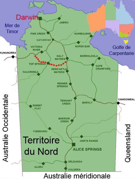
La Buchanan Highway est un axe routier long de 401 km dans le Territoire du Nord en Australie, qui va d'au sud de Daly Waters sur la Stuart Highway à 620 km au sud de Darwin à l'est jusqu'à la Victoria Highway près de Timber Creek à l'ouest en en croisant la Buntine Highway à Top Springs. La route n'est pas goudronnée sur la totalité de son trajet.
Wikimedia Foundation.
2010.
Contenu soumis à la licence CC-BY-SA. Source : Article Buchanan Highway de Wikipédia en français (auteurs)
Regardez d'autres dictionnaires:
Buchanan Highway — Von … Deutsch Wikipedia
Buchanan Highway — Infobox Australian Road road name = Buchanan Highway route route route photo = caption = length = 401 direction = West East start = finish = est = through = Gregory National Park, Victoria River Downs, Top Springs route = exits = : For the auto… … Wikipedia
Buchanan Field Airport — For the other uses, see Concord Airport (disambiguation). Buchanan Field Airport USGS Orthophoto, 2006 IATA: CCR – ICAO: KCCR … Wikipedia
Buchanan County, Iowa — Infobox U.S. County county = Buchanan County state = Iowa seallink = map size = 250 founded = 1837 seat = Independence largest city = area total sq mi = 573 area total km2 = 1485 area land sq mi = 571 area land km2 = 1480 area water sq mi = 2… … Wikipedia
Buchanan's Birthplace State Park — Geobox Protected Area name = Buchanan s Birthplace State Park native name = other name = other name1 = category local = Pennsylvania State Park category iucn = V image caption = etymology type = Named for etymology = Birthplace of James Buchanan… … Wikipedia
Buchanan, Saskatchewan — Infobox Settlement official name = Village of Buchanan other name = native name = nickname = settlement type = motto = imagesize = image caption = flag size = image seal size = image shield = shield size = city logo = citylogo size = pushpin… … Wikipedia
Buchanan County, Virginia — Infobox U.S. County county = Buchanan County state = Virginia map size = 250 founded = 1858 seat = Grundy | area total sq mi =504 area water sq mi =0 area percentage = 0.00% census yr = 2000 pop = 26978 density km2 =21 web =… … Wikipedia
Buchanan, Wisconsin — Infobox Settlement official name = Buchanan, Wisconsin settlement type = Town nickname = motto = imagesize = image caption = image mapsize = 250px map caption = Location of Buchanan, Wisconsin mapsize1 = map caption1 = subdivision type = Country… … Wikipedia
Stuart Highway — Verlauf des Stuart Highway durch Australien Der Stuart Highway ist eine der wichtigsten Fernverkehrsstraßen in Australien. Er verläuft über eine Länge von rund 2800 Kilometer in Nordsüd Richtung und verbindet die Hauptstadt Südaustraliens… … Deutsch Wikipedia
Buntine Highway — Formerly between Nicholson and Top Springs … Wikipedia
 La Buchanan Highway