's-Heerenhoek
- 's-Heerenhoek
-
51° 27′ 12″ N 3° 46′ 10″ E / 51.4533, 3.76944
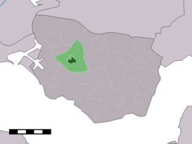
's-Heerenhoek est un village de la commune néerlandaise de Borsele, en Zélande. Le village compte 1 938 habitants en 2008[1].
Le village est apparu après la poldérisation du Borsselepolder en 1616 ; il s'appelait alors Calishoek. Il est né au point de rencontre des digues de différents polders.
En 1672, une église protestante a été bâtie ; entre-temps, depuis 1870, c'est une église catholique qui se trouve au centre du village.
's-Heerenhoek est un centre de loisirs connu de Zuid-Beveland. Le village attire chaque année beaucoup de visiteurs au cours du carnaval, quand il est rebaptisé Paerehat.
L'ex coureur cycliste Jan Raas est un habitant célèbre de 's-Heerenhoek.
Galerie
-
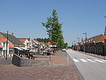
Une digue à 's-Heerenhoek.
-
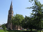
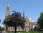
L'église catholique néo-gothique.
-
Lien externe
Source
Notes et références
Wikimedia Foundation.
2010.
Contenu soumis à la licence CC-BY-SA. Source : Article 's-Heerenhoek de Wikipédia en français (auteurs)
Regardez d'autres dictionnaires:
's Heerenhoek — Vue de la localité sur la carte des Pays Bas Pays … Wikipédia en Français
's-Heerenhoek — Town s Heerenhoek, church … Wikipedia
's-Heerenhoek — s Heerenhoek … Wikipedia Español
's-Heerenhoek — Kirche in s Heerenhoek s Heerenhoek (Seeländisch: Seêrenoek) ist ein Dorf innerhalb der Gemeinde Borsele in der niederländischen Provinz Zeeland. Das Dorf hat 1966 Einwohner (Stand: 01. Jan. 2011). Bis 1970 war s Heerenhoek eine selbstständige… … Deutsch Wikipedia
Borsele — Héraldique … Wikipédia en Français
Liste aller niederländischen Gemeinden A–L — In diese Liste werden alle Gemeinden, die auf dem Gebiet der jetzigen Niederlande bestehen oder bestanden haben, aufgenommen. Die Liste beginnt im Jahr 1805/10. Vor 1830 können die Angaben unvollständig sein. Kleinere Grenzkorrekturen oder… … Deutsch Wikipedia
Kwadendamme — 51° 26′ 00″ N 3° 52′ 39″ E / 51.4333, 3.8775 … Wikipédia en Français
Borsele — Infobox Settlement official name = Borsele mapsize = 280px subdivision type = Country subdivision name = Netherlands subdivision type1 = Province subdivision name1 = Zeeland area footnotes = (2006) area total km2 = 194.42 area land km2 = 142.03… … Wikipedia
List of places in the Netherlands — This is an alphabetical list of places (cities, towns, villages) in the Netherlands. Lists per province can be found at:* List of towns in Groningen * List of towns in Friesland * List of towns in Drente * List of towns in Overijssel * List of… … Wikipedia
Gerrie Knetemann — Infobox Cyclist ridername = Gerrie Knetemann fullname = Gerrie Knetemann nickname = de Kneet dateofbirth = birth date|1951|03|06 dateofdeath = death date and age|2004|11|02|1951|03|06 country = NED height = weight = currentteam = discipline =… … Wikipedia
 Pays-Bas


