Borough d'Arima
- Borough d'Arima
-
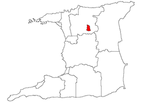
Arima
Arima est une ville de Trinité-et-Tobago située sur l'île de Trinité. Elle a le statut de borough.
Catégories : Subdivision de Trinité-et-Tobago | Ville de Trinité-et-Tobago
Wikimedia Foundation.
2010.
Contenu soumis à la licence CC-BY-SA. Source : Article Borough d'Arima de Wikipédia en français (auteurs)
Regardez d'autres dictionnaires:
Borough of Arima — Admin ASC 1 Code Orig. name Borough of Arima Country and Admin Code TT.01 TT … World countries Adminstrative division ASC I-II
Arima — Administration Pays … Wikipédia en Français
Arima — Infobox Settlement official name = The Royal Borough of Arima other name = native name = nickname = settlement type = Borough motto = imagesize = image caption = flag size = image seal size = image shield = shield size = city logo = citylogo size … Wikipedia
London Borough of Haringey — Infobox London Borough | name = London Borough of Haringey short name = Haringey imagename = status = London borough | area rank = 339th area km2 = 29.59 ons code = 00AP | adminhq = Wood Green | ethnicity = 61.7% White 22.1% African Caribbean… … Wikipedia
London Borough of Haringey — Lage in Greater London Status London Borough Region … Deutsch Wikipedia
Chaguanas — Borough of Chaguanas Chaguanas Borough Coordinates … Wikipedia
Trinidad and Tobago local election, 2008 — Local elections are due to be held in Trinidad and Tobago in June 2008. They were originally scheduled for June 2006, but were postponed for a year by Prime Minister Patrick Manning for one year. In June 2007 he delayed them for another year. The … Wikipedia
Regional corporations and municipalities of Trinidad and Tobago — Location Trinidad and Tobago Number 14 … Wikipedia
Counties of Trinidad and Tobago — Map showing old counties of Trindad Historically, Trinidad was divided into eight counties, and these counties were subdivided into Wards. Tobago was administered as a Ward of County Saint David. Caroni Mayaro Nariva Saint Andrew Saint David… … Wikipedia
Subdivisions de Trinite-et-Tobago — Subdivisions de Trinité et Tobago Trinité et Tobago est subdivisé en 15 subdivisions de premier niveau, soit 9 régions, 3 boroughs, 2 villes et la région autonome de Tobago. Subdivisions Superficie (km²) Population Densité (/km²) Principales… … Wikipédia en Français
 Trinité-et-Tobago