Woodfibre
- Woodfibre
-
49° 39′ 48″ N 123° 15′ 18″ W / 49.6633333, -123.255

Woodfibre et la
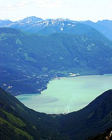
Baie Howe, vu du Mont Roderick
Woodfibre était le nom d'un village ainsi que d'un moulin à papier de la Colombie-Britannique situé non loin de la ville de Squamish, dans le District régional de Squamish-Lillooet. Le moulin a fermé en 2006.
Histoire
En 1912, une usine de transformation du bois s'implanta à l'embouchure du Mill Creek, sur les rives de la Baie Howe. Un village fut aussitôt construit pour accueillir les familles des travailleurs, le seul accès aussi se faisant par bateau.
Jusqu'aux années 1960, les familles y ont vécu, travaillé, et même partiellement été éduqués sur place. À partir de ce moment, les familles ont commencé à quitter le campement et à retourner s'établir dans les villes voisines, telles que Squamish ou Britannia Beach, et le village fut graduellement abandonné et démoli.
La compagnie exploitante du moulin fournissait un service de traversier privé jusqu'à la fermeture du moulin en 2006.

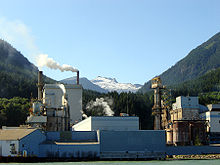
Le moulin à papier de Woodfibre, CB.
|

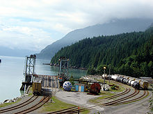
Les rails et le terminal du traversier de Woodfibre, CB.
|

Woodfibre, vu de Britannia Beach
|
Catégorie :
- Communauté de Colombie-Britannique
Wikimedia Foundation.
2010.
Contenu soumis à la licence CC-BY-SA. Source : Article Woodfibre de Wikipédia en français (auteurs)
Regardez d'autres dictionnaires:
Woodfibre, British Columbia — Woodfibre was a pulp mill and at one time a small town, on the west side of upper Howe Sound near Squamish, British Columbia. The mill closed in March 2006.HistoryIn 1912, a mill opened at the site where Mill Creek empties into Howe Sound. The… … Wikipedia
Howe Sound — is a roughly triangular sound, actually a network of fjords situated immediately northwest of Vancouver. GeographyHowe Sound s mouth at the Strait of Georgia is situated between West Vancouver and the Sunshine Coast. The sound is triangular… … Wikipedia
Princess Louise (sidewheeler) — Princess Louise, at Masset, BC, circa 1880. Career Nam … Wikipedia
List of communities in British Columbia — This is a list of communities in British Columbia, a province in Canada. For the purposes of this list, a community is defined as either an incorporated municipality (including Indian reserves), or an unincorporated settlement inside or outside… … Wikipedia
Squamish-Lillooet Regional District — Squamish Lillooet is a regional district in British Columbia, Canada. It stretches from Britannia Beach in the south to Pavilion in the north. Lillooet, Pemberton, Whistler and Squamish are the four municipalities in the regional district. Its… … Wikipedia
Pacific Ranges — Geobox|Range name=Pacific Ranges image caption=Mount Garibaldi country=Canada region type=Province region=British Columbia parent=Coast Mountains highest=Mount Waddington highest elevation=4016 highest lat d=51|highest lat m=22|highest lat… … Wikipedia
Shannon Falls Provincial Park — is a provincial park in British Columbia, Canada. It is located km to mi|58 from Vancouver and km to mi|2 south of Squamish along the Sea to Sky Highway. The park covers an area of 87 hectares. The main point of interest is the third highest… … Wikipedia
University of Auckland, Faculty of Engineering — Infobox University Faculty name=Faculty of Engineering| native name=Te Waka Wewete Panga type=Public dean=Professor Michael C.R. Davies staff=362 students=2,353 undergrad=1,996 postgrad=386 website=http://www.engineering.auckland.ac.nz/ footnotes … Wikipedia
List of company towns — This is a List of company towns.Towns listed in bold are still considered company towns today; other entries are former company towns. See for an unannotated list of articles. Europe Belgium * Louvain la Neuve, home of the Université Catholique… … Wikipedia
Liste Des Municipalités De La Colombie-Britannique — Liste des cantons, municipalités, villages et villes de la province de la Colombie Britannique au Canada. Sommaire : Haut A B C D E F G H I J K L M N O P Q R S T U V W X Y Z … Wikipédia en Français
 Woodfibre et la Baie Howe, vu du Mont Roderick


