Wollombi
Contenu soumis à la licence CC-BY-SA. Source : Article Wollombi de Wikipédia en français (auteurs)
Regardez d'autres dictionnaires:
Electoral district of Wollombi — Wollombi was a former electoral district for the Legislative Assembly in the Australian state of New South Wales from 1859 to 1894. Members for Wollombi … Wikipedia
Cessnock, New South Wales — Cessnock New South Wales Cessnock, New South Wales … Wikipedia
Capers Guesthouse and Cottage — (Wollombi,Австралия) Категория отеля … Каталог отелей
Blaxland-Expedition — Route der Blaxland Expedition Die Blaxland Expedition unter der Führung von Gregory Blaxland durchquerte vom 11. Mai bis zum 6. Juni 1813 die Blue Mountains in Australien. Blaxland und seine Begleiter William Lawson und William Wentworth galten… … Deutsch Wikipedia
Biamie — In Aboriginal mythology Biamie was the Creator God of the several Aboriginal tribes that surrounded Lake Macquarie in New South Wales, Australia [Wright.T Belongs the Kamilaroi people] [Faith.J Aboriginal Studies student] [Yengo National Park… … Wikipedia
Members of the New South Wales Legislative Assembly, 1859–1860 — This is a list of members of the New South Wales Legislative Assembly from 1859 to 1860: Name Electorate Years in office Arnold, William MunningsWilliam Arnold Paterson 1856–1875 Asher, MorrisMorris Asher Hume 1859–1860 … Wikipedia
City of Cessnock — Cessnock, New South Wales Location in New South Wales Popula … Wikipedia
Great North Road, Australia — The Great North Road is a historic road in New South Wales, Australia. It extends north from Sydney and was the first road to link Sydney with the fertile Hunter Valley.Constructed with convict labour between 1825 and 1836, it extends for over… … Wikipedia
Northumberland County, New South Wales — Map of all coordinates from Google Map of all coordinates from Bing Export all coordinates as KML … Wikipedia
Hunter River (New South Wales) — Hunter River Schiff an der Mündung des Hunter River bei NewcastleVorlage:Infobox Fluss/KARTE fehlt … Deutsch Wikipedia
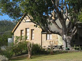
 L'école de Wollombi
 Australie

