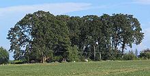
Willamette Valley forests
- Willamette Valley forests
-
L'écorégion appelée par le WWF Willamette Valley forests (littéralement « Forêts de la vallée de la Willamette » ) est une zone qui s’étend aux États-Unis dans la vallée de la rivière Willamette et d'une petite partie du bassin du fleuve Columbia. La zone est située dans les États de l'Oregon et de Washington au nord-ouest des États-Unis. Cette écorégion occupe 14 900 km2 d'une zone comprise entre la chaîne côtière de l'Oregon à l'ouest et la chaîne des Cascades à l'est[1].
Suite au développement de l'agriculture dans la région, une grande partie de la zone a perdu son état naturel initial. Seule une toute petite proportion de la zone a conservé ses zones de prairies couvertes de chênes parsemés. Cette zone était restaurée par des incendies naturels ou causés par les Amérindiens. Mais la suppression de ces incendies fait que les prairies se font coloniser petit à petit par des arbres[1]. La vallée est le seul endroit au monde à accueillir la fleur jaune Lomatium bradshawii. Le chêne principal qui pousse dans la région est le chêne de Garry[1].
Voir aussi
Notes et références
Liens externes
Wikimedia Foundation.
2010.
Contenu soumis à la licence CC-BY-SA. Source : Article Willamette Valley forests de Wikipédia en français (auteurs)
Regardez d'autres dictionnaires:
Willamette Valley forests — The Willamette Valley forests is a temperate mixed forest ecoregion of Oregon and Washington in the western United States.ettingThe ecoregion covers an area of 14,900 square kilometers (5,800 square miles), lying mostly in Oregon, with a small… … Wikipedia
Willamette Valley (ecoregion) — The Willamette Valley ecoregion is a Level III ecoregion designated by the United States Environmental Protection Agency (EPA) in the U.S. states of Oregon and Washington. Slightly larger than the Willamette Valley for which it is named, the… … Wikipedia
Willamette — can refer to:A toponym of the U.S. state of Oregon: * Willamette River, a tributary of the Columbia River in northwestern Oregon * Willamette Valley, a region in northwest Oregon that surrounds the Willamette River * Willamette Valley forests, an … Wikipedia
Willamette River — River, northwestern Oregon, U.S. It flows north for 300 mi (485 km) into the Columbia River near Portland. Oregon s most populous cities are in its valley. The Fremont Bridge, a steel arch with a main span of 1,225 ft (373 m), crosses the river… … Universalium
Johnson Creek (Willamette River) — Geobox | River name = Johnson Creek category = Creek image size = 300 image caption = Johnson Creek near Regner Road in Gresham etymology = William Johnson, early settler country = United States country state = Oregon district type = County… … Wikipedia
Christmas Valley Sand Dunes — Coordinates: 43°18′43″N 120°25′55″W / 43.31203°N 120.43183°W / 43.31203; 120.43183 … Wikipedia
Columbia (fleuve) — Pour les articles homonymes, voir Columbia. Cet article possède un homophone, voir Colombia. Columbia (Columbia River, Wimahl, Nch’i Wàna) … Wikipédia en Français
List of ecoregions (WWF) — This is a list of ecoregions as compiled by the World Wildlife Fund (WWF). The WWF identifies terrestrial, freshwater, and marine ecoregions.The terrestrial scheme divides the Earth s land surface into 8 terrestrial ecozones, containing 867… … Wikipedia
Nearctic ecozone — For the thoroughbred racehorse, see Nearctic (horse). The Nearctic is one of the eight terrestrial ecozones dividing the Earth s land surface. The Nearctic Ecozone The Nearctic ecozone covers most of North America, including Greenland and the… … Wikipedia
List of ecoregions in the United States (WWF) — This is a list of terrestrial ecoregions of the 50 United States and Puerto Rico, as defined by the World Wildlife Fund:Tropical and subtropical moist broadleaf forests* Hawaii tropical moist forests * Puerto Rican moist forests * South Florida… … Wikipedia

