Walpeup
Contenu soumis à la licence CC-BY-SA. Source : Article Walpeup de Wikipédia en français (auteurs)
Regardez d'autres dictionnaires:
Walpeup, Victoria — Infobox Australian Place | type = town name = Walpeup state = vic caption = lga = Rural City of Mildura postcode = 3507 pop = 108 (2006)Census 2006 AUS | id = SSC26909 | name = Walpeup (State Suburb) | accessdate = 2007 10 01 | quick = on] est =… … Wikipedia
Shire of Walpeup — Infobox Australian Place | type = lga name = Shire of Walpeup state = vic region = area = 10964 est = 1911 seat = Ouyen pop = 3310 (1992) [cite book|title=Victorian Year Book|author=Australian Bureau of Statistics, Victoria… … Wikipedia
Mallee Football League (Victoria) — The Mallee Football League is an Australian rules football league based in the Mallee region of northwestern Victoria. It is not to be confused with the identically named Mallee Football League (South Australia). Contents 1 History 2 Clubs 2.1… … Wikipedia
Mallee Highway — Formerly … Wikipedia
Mallee Highway — mit eine … Deutsch Wikipedia
Rural City of Mildura — Victoria Location in Victoria Population … Wikipedia
Shire of Karkarooc — Infobox Australian Place | type = lga name = Shire of Karkarooc state = vic region = area = 3719 est = 1896 seat = Hopetoun pop = 2720 (1992) [cite book|title=Victorian Year Book|author=Australian Bureau of Statistics, Victoria… … Wikipedia
Shire of Mildura — Infobox Australian Place | type = lga name = Shire of Mildura state = vic region = area = 10145 est = 1890 seat = Irymple pop = 21230 (1992) [cite book|title=Victorian Year Book|author=Australian Bureau of Statistics, Victoria… … Wikipedia
City of Mildura — Victoria Location in Victoria Population: 20350 (1992)[1] … Wikipedia
Shire of Dimboola — Infobox Australian Place | type = lga name = Shire of Dimboola state = vic region = Wimmera area = 4856 est = 1885 seat = Dimboola pop = 4,280 (1992) [cite book|title=Victorian Year Book|author=Australian Bureau of Statistics, Victoria… … Wikipedia
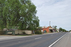 La Mallee Highway à Walpeup

