Tolga (Queensland)
Contenu soumis à la licence CC-BY-SA. Source : Article Tolga (Queensland) de Wikipédia en français (auteurs)
Regardez d'autres dictionnaires:
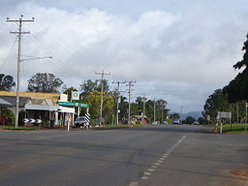
Tolga, Queensland — Infobox Australian Place | type = town name = Tolga state = qld caption = Main street of Tolga. lga = Tablelands Regional Council postcode = 4882 est = pop = 410(M) 383(F) 793(total)(2001 census) elevation= maxtemp = mintemp = rainfall = stategov … Wikipedia
Tolga — can be:* A municipality in the Wilaya of Biskra in Algeria, see Tolga, Algeria. * A municipality in the county of Hedmark in Norway, see Tolga, Norway. * A town in the Tablelands in Far North Queensland, Australia, see Tolga, Queensland. * A male … Wikipedia
Tolga — Cette page d’homonymie répertorie les différents sujets et articles partageant un même nom. Tolga désigne différentes localités : Tolga, une commune algérienne de la wilaya de Biskra, Tolga, un village du Queensland, en Australie, Tolga, une … Wikipédia en Français
Tandara, Queensland — Infobox Australian Place | type = town name = Tandara state = qld caption = A house on Appaloosa Cr lga = Tablelands Regional Council postcode = 4882 est = pop = 410(M) 383(F) 793(total)(2001 census) elevation= maxtemp = mintemp = rainfall =… … Wikipedia
Atherton (Queensland) — Atherton Die Hauptstraße von Atherton Staat … Deutsch Wikipedia
Malanda, Queensland — Malanda Queensland Malanda Hotel … Wikipedia
Mareeba, Queensland — Mareeba redirects here. For the WWII freighter, see SS Mareeba. Mareeba Queensland … Wikipedia
Dimbulah, Queensland — Dimbulah Queensland … Wikipedia
Millaa Millaa, Queensland — Millaa Millaa Queensland The Millaa Millaa lookout (also called Gentle Annie lookout) presents 180 degree views from the northwest to the southeast of the Atherton Tableland … Wikipedia
Atherton, Queensland — Infobox Australian Place | type = town name = Atherton state = qld caption = The main street of Atherton lga = Tablelands Regional Council postcode = 4883 pop = 5800 est = rainfall = 1360 elevation = 700 stategov = Electoral district of… … Wikipedia
 Pour les articles homonymes, voir Tolga.
 Australie


