Tasman Highway
- Tasman Highway
-
...
 |
Tasman Highway
Longueur : 410 km |
|
|
| Liste des croisements |
|
|
1 |
Brooker Highway, Hobart |
|
|
2 |
Domain Highway |
|
|
3 |
East Derwent Highway |
|
|
4 |
South Arm Highway |
|
|
5 |
Cambridge Road |
|
|
6 |
Arthur Highway |

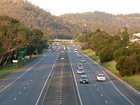
La Tasman Highway à Warrane, dans la banlieue de Hobart. |
modifier  |
La Tasman Highway est un axe routier de la Tasmanie en Australie.
Orientée nord-est-sud-ouest et longue de 410 km, elle relie Launceston à Hobart en longeant la côte est sur la plus grande partie de son trajet
Elle traverse du sud au nord les villes et villages de Hobart, Orielton, Runnymede, Buckland, Orford, Swansea,le Parc national Freycinet, Bicheno, St Marys, Scamander, St Helens, Scottsdale et Launceston
Wikimedia Foundation.
2010.
Contenu soumis à la licence CC-BY-SA. Source : Article Tasman Highway de Wikipédia en français (auteurs)
Regardez d'autres dictionnaires:
Tasman Highway — Infobox Australian Road road name = Tasman Highway type = State highway route route route photo = Tasman hwy.jpg caption = The Eastern Outlet at Cambridge Formerly .] length = 410 direction = Southwest Northeast start = finish = George Street,… … Wikipedia
Tasman Highway — Der Tasman Highway ist eine Fernverkehrsstraße in Tasmanien, Australien. Der Tasman Highway hat eine Länge von 410 Kilometern, was ihn zu einem der längsten Highways in Tasmanien macht. Er folgt im Wesentlichen dem Verlauf der Nordost und… … Deutsch Wikipedia
Tasman — may refer to:People* Tasman Clingan (born 1988), Australian Rules Football player * Raymond Tasman Donoghue (1920 1960), Australian tram driver posthumously awarded the George Cross * Lindsay Tasman Ride (1898 1977), Australian physiologist,… … Wikipedia
Tasman Bridge — Infobox Bridge bridge name=Tasman Bridge caption= official name= carries= crosses=Derwent River locale=Hobart, Tasmania maint=Department of Infrastructure, Energy and Resources id= design=Prestressed concrete Girder mainspan= length=1,395 meters… … Wikipedia
Tasman Peninsula — is located around 75 km by road south east of Hobart, at the south east corner of Tasmania, Australia. LocationTasman Peninsula lies south and west of Forestier Peninsula, to which it is connected by an isthmus called Eaglehawk Neck. This in turn … Wikipedia
Tasman Peninsula — Peninsula, southeastern Tasmania, Australia. About 26 mi (42 km) long by 20 mi (32 km) wide, it has sea cliffs and unusual rock formations. First explored in 1642, it was not settled until a penal colony was established at Port Arthur in 1830.… … Universalium
Brooker Highway — The … Wikipedia
Domain Highway — Length 2.1 km (1 mi) Direction southeast northwest … Wikipedia
Midland Highway (Tasmania) — Midland Highway Midland Highway, at Dysart … Wikipedia
Esk Highway — Infobox Australian Road road name = Esk Highway route route route photo = caption = Formerly .] length = 65 direction = West East start = finish = est = through = Avoca, Fingal, St Marys route = A4 exits = Elephant Pass RoadThe Esk Highway (route … Wikipedia


