Tarčin

Tarčin

43° 47′ 35″ N 18° 05′ 51″ E / 43.7931, 18.0975

Tarčin
Administration
Pays Drapeau de Bosnie-Herzégovine Bosnie-Herzégovine
Entité Drapeau de la Fédération de Bosnie-et-Herzégovine Fédération de Bosnie-et-Herzégovine
Canton Sarajevo
Municipalité Hadžići
Géographie
Coordonnées 43° 47′ 35″ Nord
       18° 05′ 51″ Est
/ 43.7931, 18.0975
Démographie
Population 1 005 hab. (1991)
Localisation
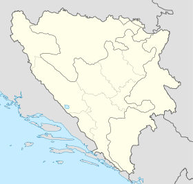
Bosnia and Herzegovina location map.svg
City locator 15.svg
Tarčin

Tarčin (en cyrillique : Тарчин) est un village de Bosnie-Herzégovine. Il est situé dans la municipalité de Hadžići et dans le canton de Sarajevo, Fédération de Bosnie-et-Herzégovine. Au recensement de 1991, il comptait 1 005 habitants, dont une majorité relative de Musulmans (Bosniaques)[1].

Sommaire

Démographie

Répartition de la population (1991)

Nationalité Nombre %
Musulmans 413 41,09
Serbes 246 24,47
Croates 168 16,71
Yougoslaves 130 12,93
Inconnus/autres 48 4,77[1]

En 1991, la communauté locale de Tarčin comptait 2 248 habitants, répartis de la manière suivante[2] :

Nationalité Nombre %
Musulmans 1 356 60,32
Serbes 518 23,04
Croates 181 8,05
Yougoslaves 135 6,01
Inconnus/autres 58 2,59

Notes et références

  1. a et b (bs)(hr)(sr) Livre : Composition nationale de la population - Résultats de la République par municipalités et localités 1991, Bulletin statistique n°234, Publication de l'Institut national de statistique de Bosnie-Herzégovine, Sarajevo.
  2. (bs)(hr)(sr)[PDF] Recensement par communautés locales sur http://www.fzs.ba, Bosnie-Herzégovine - Fédération de Bosnie-et-Herzégovine - Institut fédéral de statistique. Consulté le 11 octobre 2010

Voir aussi

Articles connexes

Liens externes


Wikimedia Foundation. 2010.

Contenu soumis à la licence CC-BY-SA. Source : Article Tarčin de Wikipédia en français (auteurs)

Игры ⚽ Поможем написать реферат

Regardez d'autres dictionnaires:

  • Tarcin Alacati Hotel — (Алачати,Турция) Категория отеля: Адрес: Alaçatı Mah. 5006. Sok. Alaçatı İzmir …   Каталог отелей

  • tarçın — is., bit. b., Far. dārçīn 1) Defnegillerden, genellikle Asya nın güneyinde yetişen ve değişik türleri bulunan bir ağaç (Cinnamomum) 2) Bu ağacın, içinde kokulu bir yağ bulunması dolayısıyla baharat gibi kullanılan kabuğu Sakalının rengi kınaya,… …   Çağatay Osmanlı Sözlük

  • tarçın tartmak — dar içün tartmak, ah çekmek, inlemek, nale eylemek …   Çağatay Osmanlı Sözlük

  • koku — tarçın (kuru yapımında kullanılan madde) …   Beypazari ağzindan sözcükler

  • Corridor Vc — ( Corridor 5c ) is a branch of the fifth Pan European corridor. The path of the corridor is presently the European route E73, and a new highway is being constructed as part of the upgrade of the corridor. Vc connects Budapest in Hungary to the… …   Wikipedia

  • Hadžići (canton de Sarajevo) — Pour les articles homonymes, voir Hadžići. 43° 49′ 20″ N 18° 12′ 24″ E …   Wikipédia en Français

  • Hadžići — Infobox Settlement official name = Hadžići settlement type = subdivision type = Country subdivision name = BIH timezone=CET utc offset=+1 map caption =Location of Hadžići within Bosnia and Herzegovina. timezone DST=CEST utc offset DST=+2 latNS=N… …   Wikipedia

  • List of settlements in Bosnia and Herzegovina — This is a complete list of settlements in Bosnia and Herzegovina, as recorded by 1991 census, sorted by municipalities. Town of Sarajevo = Sarajevo Centar = • Mrkovići • Nahorevo• Poljine• Radava• Sarajevo (part of settlement)• Vića Sarajevo… …   Wikipedia

  • A1 (Bosnien und Herzegowina) — Vorlage:Infobox hochrangige Straße/Wartung/BA A Autoput A1 in Bosnien und Herzegowina …   Deutsch Wikipedia

  • Kiseljak — Кисељак …   Deutsch Wikipedia

Share the article and excerpts

Direct link
Do a right-click on the link above
and select “Copy Link”