Swale (district)
- Swale (district)
-
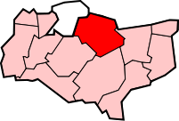
Swale est un district non-métropolitain du Kent avec le statut de borough, En Angleterre. Son conseil est basé à Sittingbourne. Le district est nommé d'après le canal étroit appelé Le Swale, soit un canal qui sépare le continent de l'Île de Sheppey, et qui occupe la partie centrale du district. La gare de Swale est à l'extrémité sud du Pont de Kingsferry. Il y a quatre villes de l'arrondissement: Sittingbourne et Faversham sur le continent; Sheerness et Queenborough sur l'île.
Liste des paroisses du borough de Swale
- Bapchild
- Bobbing
- Borden
- Boughton-under-Blean
- Bredgar
- Conyer
- Doddington
- Dunkirk
- Eastchurch
- Eastling
- Faversham
- Goodnestone
- Graveney
- Hartlip
- Hernhill
- Iwade
- Leysdown
- Lower Halstow
- Lynsted
- Kemsley
- Milstead
- Milton Regis
- Minster-on-Sea
- Murston
- Newington
- Newnham
- Norton Buckland & Stone
- Oare
- Ospringe
- Rodmersham
- Rushenden
- Selling
- Sheldwich, Badlesmere and Leaveland
- Stalisfield
- Teynham
- Throwley
- Tonge
- Tunstall
- Warden
Catégorie :
- District non-métropolitain du Kent
Wikimedia Foundation.
2010.
Contenu soumis à la licence CC-BY-SA. Source : Article Swale (district) de Wikipédia en français (auteurs)
Regardez d'autres dictionnaires:
Swale — Cette page d’homonymie répertorie les différents sujets et articles partageant un même nom. Swale peut signifier: Swale, district local du Kent en Angleterre Swale, bande de mer entre l’Île de Sheppey et le nord du Kent en Angleterre Swale,… … Wikipédia en Français
Swale — is a local government district in Kent, England. Its council is based in Sittingbourne. The borough is named after the narrow channel called The Swale, a channel that separates the mainland of Kent from the Isle of Sheppey, and which occupies the … Wikipedia
Swale (disambiguation) — Swale is a local government district in Kent, England.Swale may also refer to: * The Swale, a strip of water separating North Kent from the Isle of Sheppey, England * River Swale, in North Yorkshire, England * Swale (geographical feature), a low… … Wikipedia
Swale — Borough of Swale Lage in Kent Status Borough Region South East England Verw.grafschaft Kent Verwaltungssi … Deutsch Wikipedia
swale — /swayl/, n. Chiefly Northeastern U.S. 1. a low place in a tract of land, usually moister and often having ranker vegetation than the adjacent higher land. 2. a valleylike intersection of two slopes in a piece of land. [1400 50; late ME; orig. a… … Universalium
Minster, Swale — Not to be confused with Minster in Thanet. Coordinates: 51°25′16″N 0°48′32″E / 51.421°N 0.809°E / 51.421; 0.809 … Wikipedia
Myton-on-Swale — Coordinates: 54°05′38″N 1°19′52″W / 54.094°N 1.331°W / 54.094; 1.331 … Wikipedia
Crouch, Swale — Crouch is a hamlet in the civil parish of Boughton under Blean in the Swale District, in the county of Kent, England. Nearby settlements include the town of Faversham and the villages of Selling, Gushmere, South Street and Neames Forstal.… … Wikipedia
List of District Health Authorities in England and Wales — District Health Authorities were administrative units of the National Health Service in England and Wales from 1982 to 1996. The districts were a second tier below the health regions. They replaced the Area Health Authorities (which generally… … Wikipedia
Dales & District — A Dales District Optare Solo. Parent Procters Coaches … Wikipedia