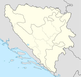
Sulice
- Sulice
-
43° 59′ 15″ N 19° 25′ 27″ E / 43.9875, 19.4242
Sulice (en serbe cyrillique : Сулице) est un village de Bosnie-Herzégovine. Il est situé dans la municipalité de Srebrenica, République serbe de Bosnie. Au recensement de 1991, il comptait 712 habitants, dont une majorité de Musulmans (Bosniaques)[1].
Démographie
Répartition de la population (1991)
Notes et références
- ↑ a et b (bs)(hr)(sr) Livre : Composition nationale de la population - Résultats de la République par municipalités et localités 1991, Bulletin statistique n°234, Publication de l'Institut national de statistique de Bosnie-Herzégovine, Sarajevo.
Voir aussi
Articles connexes
Liens externes
Catégories : - Localité de Srebrenica
- Localité de Srebrenica à majorité bosniaque
Wikimedia Foundation.
2010.
Contenu soumis à la licence CC-BY-SA. Source : Article Sulice de Wikipédia en français (auteurs)
Regardez d'autres dictionnaires:
Dobrejowitz — Dieser Artikel beschreibt die Gemeinde Dobřejovice. Für den gleichnamigen Ortsteil von Hosín, siehe dort. Dobřejovice … Deutsch Wikipedia
Dobřejovice — Dobřejovice … Deutsch Wikipedia
Srebrenica — 44° 06′ 23″ N 19° 17′ 49″ E / 44.1064, 19.2969 … Wikipédia en Français
Ondřejov (Prague-East District) — Church in the village Ondřejov (Czech pronunciation: [ˈondr̝ɛjof]) is a village in Central Bohemian Region of the Czech Republic. It has around 1,100 inhabitants. Villages Třemblat and Turkovice are administrative parts of Ondřejov. The… … Wikipedia
Mochov — Church of St Bartholomew … Wikipedia
Měšice — (Prague East District) Municipality and village Country Czech Republic Region … Wikipedia
Prague-East District — District of Prague East Okres Praha východ District Church of St. Wenceslaus from 12th century in Hrusi … Wikipedia
Nová Ves (Prague-East District) — Nová Ves is a village in the Prague East District, Central Bohemian Region of the Czech Republic. On the date July 3, 2006 it has 250 inhabitants. First written notice about village is from year 1455. Its a member of Mikroregion Povodí… … Wikipedia
Mratín — Saint Michael church, Mratin Mratín is a village in the Prague East District, Central Bohemian Region of the Czech Republic. On the date August 28, 2006 it has 760 inhabitants. First written notice about village is from year 1379. Its a member of … Wikipedia
Černé Voděrady — is a village in the Central Bohemian Region of the Czech Republic. On the date July 3, 2006 it has 293 inhabitants. First written notice about village is from year 1291. The municipality lies at an altitude of 425 metres and covers an area of… … Wikipedia
 Bosnie-Herzégovine
 République serbe de Bosnie
