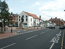
Spilsby
Contenu soumis à la licence CC-BY-SA. Source : Article Spilsby de Wikipédia en français (auteurs)
Regardez d'autres dictionnaires:
Spilsby — Infobox UK place official name= Spilsby country= England region= East Midlands population= 2,336 (Parish) os grid reference= TF4066 latitude= 53.17270 longitude= 0.09310 post town= SPILSBY postcode area= PE postcode district= PE23 dial code=… … Wikipedia
Spilsby — 53.17270.093099999999993 Koordinaten: 53° 10′ N, 0° 6′ O … Deutsch Wikipedia
Spilsby — Original name in latin Spilsby Name in other language State code GB Continent/City Europe/London longitude 53.17363 latitude 0.09373 altitude 50 Population 2807 Date 2010 05 24 … Cities with a population over 1000 database
Spilsby railway station — Infobox UK disused station name = Spilsby gridref = TF677334 caption = Spilsby railway station c.1890. owner = Great Northern Railway Eastern Region of British Railways locale = Spilsby borough = East Lindsey, Lincolnshire platforms = 2 years = 1 … Wikipedia
Spilsby Rural District — infobox historic subdivision Name= Spilsby HQ= Spilsby Status= Rural district Start= 1894 End= 1974 Replace= East Lindsey PopulationFirst= 20,506 PopulationLast= 22,459 PopulationFirstYear= 1901 PopulationLastYear= 1971 AreaFirst=… … Wikipedia
RAF Spilsby — Infobox Airport name = RAF Spilsby nativename = nativename a = nativename r = image width = caption = A memorial in All Saints Church, Great Steeping to the members of 44 Squadron who flew from Spilsby type = Decommissioned and closed in the… … Wikipedia
Asgarby, Spilsby — infobox UK place country = England static static image caption= latitude= 53.17 longitude= 00.01 official name =Asgarby population = shire district= shire county= Lincolnshire metropolitan borough= metropolitan county = region=East Midlands… … Wikipedia
Firsby — Infobox UK place official name= Firsby country= England region= East Midlands population= 276 os grid reference= latitude= 53.149 longitude= 00.182 map type= Lincolnshire post town= SKEGNESS postcode area= PE postcode district= PE24 dial code=… … Wikipedia
Keal Cotes — Infobox UK place official name= Keal Cotes country= England region= East Midlands population= Approx 100 os grid reference= TF365611 latitude= 53.125 longitude= 00.038 map type= Lincolnshire post town= SPILSBY postcode area= PE postcode district … Wikipedia
Telephone numbers in the United Kingdom — +44 redirects here. For the band, see +44 (band). United Kingdom telephone numbers Location of United Kingdom (dark green) Location Country United Kingdom Continent … Wikipedia
 Spilsby
