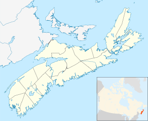
Saulnierville
- Saulnierville
-
44° 15′ 57″ N 66° 07′ 50″ W / 44.265947, -66.130657
Saulnierville est un village de pêche du comté de Digby en Nouvelle-Écosse. Il fait partie de la municipalité de district de Clare.
Saulnierville abrite la plus importante usine de transformation de poisson, la Comeau Sea Foods, qui a débuté ses opération en 1946. Il a aussi l'une des plus vieilles églises de la région, Sacré-Cœur, qui fut érigée en 1880.
Le village fut fondé en 1785 par un dénommé Saulnier qui avait reçu une concession du roi de France quand il vint en Amérique.
Culture
Personnalités
- Ambroise-Hilaire Comeau (Bas-Saulnierville, 1859 - ?, 1911), cordonnier, commerçant et homme politique;
- Léger Comeau (Saulnierville, 1920 - ?, 1996), prêtre, professeur, administrateur, entrepreneur culturel et nationaliste acadien.
Références
Wikimedia Foundation.
2010.
Contenu soumis à la licence CC-BY-SA. Source : Article Saulnierville de Wikipédia en français (auteurs)
Regardez d'autres dictionnaires:
Saulnierville, Nova Scotia — Saulnierville is a rural fishing village that was founded in 1785. It contains the French Shore s largest fish processing plant, Comeau Sea Foods, which has been in operations since 1946. Also Saulnierville has one of the oldest churches in the… … Wikipedia
Clare, Nova Scotia — Clare Municipal district Seal … Wikipedia
Nova Scotia Highway 101 — Map of all coordinates from Google Map of all coordinates from Bing Export all coordinates as KML … Wikipedia
List of communities in Nova Scotia — This is a list of communities in the Canadian province of Nova Scotia, as designated by the Union of Nova Scotia Municipalities. Incorporated municipalities in Nova Scotia are either counties, towns or regional municipalities. There are no… … Wikipedia
List of schools in Nova Scotia — Nearly all primary and secondary schools in the province of Nova Scotia are public schools maintained by the provincial government s Department of Education. While providing guidelines, the government divides administration of public education… … Wikipedia
Area code 902 — is the telephone area code in the Canadian provinces of Nova Scotia and Prince Edward Island, encompassing the whole of both provinces. The 902 Area Code was originally established in 1947 for all three Maritime provinces, with Newfoundland and… … Wikipedia
Clare (electoral district) — Clare Nova Scotia House of Assembly provincial electoral district Member of the Legislative Assembly … Wikipedia
Conseil scolaire acadien provincial — The Conseil scolaire acadien provincial is the Francophone school board for Nova Scotia. It was created in 1996. Contents 1 Région Nord Est (Northeastern Region) 2 Région Centrale (Central Region) … Wikipedia
List of communities in Digby County, Nova Scotia — List of communities in Digby County, Nova ScotiaCommunities are ordered by the highway upon which they are located. All routes start with the terminus located near the largest community.Trunk Routes*Trunk 1: Smiths Cove Weymouth North Weymouth St … Wikipedia
Alliance des radios communautaires du Canada — L Alliance des radios communautaires du Canada (ARC du Canada) a été créée en 1991. Il s agit d un organisme national qui assure la gestion du dossier de la radiodiffusion communautaire en milieu minoritaire francophone et acadien au Canada. Tant … Wikipédia en Français

