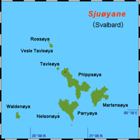
Rossøya

Rossøya
Rossøya
Carte des Sjuøyane avec Rossøya.
Géographie
Pays Drapeau de Norvège Norvège
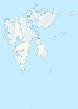
Archipel Sjuøyane(Svalbard)
Localisation Océan Arctique
Coordonnées 80° 49′ 30″ N 20° 20′ 30″ E / 80.825, 20.34166780° 49′ 30″ N 20° 20′ 30″ E / 80.825, 20.341667
Géologie Île continentale
Administration
Drapeau de Norvège Norvège
Territoire Svalbard
Démographie
Population Aucun habitant
Autres informations
Découverte 1618
Fuseau horaire UTC+1

Géolocalisation sur la carte : Svalbard

(Voir situation sur carte : Svalbard)
Rossøya
Rossøya
Îles de Norvège

Rossøya, terme norvégien signifiant littéralement « île de Ross », est une île de Norvège située dans l'océan Arctique. Elle constitue l'île la plus au nord du petit archipel des Sjuøyane dans l'archipel du Svalbard et de ce fait, elle est la terre la plus septentrionale de la Norvège avec 80° 49′ 30″ N.

L'île se trouve à 350 kilomètres au nord de Longyearbyen, à 50 kilomètres au nord de la côte septentrionale de Nordaustlandet et à 1 024 kilomètres du pôle Nord. Son nom provient de l'explorateur britannique James Clark Ross qui fit partie d'une expédition polaire en 1827 sur le HMS Hecla, sous la direction de William Edward Parry.

Référence


Wikimedia Foundation. 2010.

Contenu soumis à la licence CC-BY-SA. Source : Article Rossøya de Wikipédia en français (auteurs)

Игры ⚽ Нужно сделать НИР?

Regardez d'autres dictionnaires:

  • Rossøya — (English: Ross Island ) is a part of Sjuøyane in the Svalbard archipelago, just north of the coast of Nordaustlandet. The island is the northernmost point in the Kingdom of Norway, the distance to the North Pole is 1024.3 km (637 mi / 553 nm).The …   Wikipedia

  • Остров Росса (Шпицберген) — Остров Росса норв. Rossøya …   Википедия

  • Steigen Sjøhus — (Rossoya,Норвегия) Категория отеля: Адрес: Røssøy, 8289 Rossoya, Норвегия Оп …   Каталог отелей

  • Sjuøyane — (English: Seven Islands ) is the northernmost part of the Svalbard archipelago, just north of Nordaustlandet. As the name implies, this is a group of seven islands (as well as several islets and skerries), although three are mere islets. The… …   Wikipedia

  • Islas Sjuøyane — (Sjuøyane) Localización de grupo de pequeñas islas en el archipiélago de las islas Svalbard …   Wikipedia Español

  • Sjuøyane — Carte des Sjuøyane. Géographie Pays …   Wikipédia en Français

  • Nordkapp — This article is about the municipality in Finnmark, Norway. For the North Cape (Norwegian: Nordkapp), see North Cape, Norway. Nordkapp kommune   Municipality   …   Wikipedia

  • List of islands in the Arctic Ocean — This is a list of islands in the Arctic Ocean, classified by country.Canada*Canadian Arctic Archipelago **Queen Elizabeth Islands ***Axel Heiberg Island ***Ellesmere Island ***Devon Island ***Melville Island **Baffin Island **Banks Island… …   Wikipedia

  • Extreme points of Europe — This is a list of the extreme points of Europe, the points that are farther north, south, east or west than any other location in Europe. The northernmost point of the continent is often incorrectly given as North Cape actually the second… …   Wikipedia

  • Extreme points of Norway — This is a list of the extreme points of Norway, the points that are farther north, south, east or west than any other location. Norway * Northernmost Point mdash; Rossøya, Svalbard (80° 49′44″ N) * Southernmost Point mdash; Bouvetøya, South… …   Wikipedia

Share the article and excerpts

Direct link
Do a right-click on the link above
and select “Copy Link”