Podlugovi

Podlugovi

43° 58′ 06″ N 18° 15′ 38″ E / 43.9683, 18.2606

Podlugovi
Подлугови
Administration
Pays Drapeau de Bosnie-Herzégovine Bosnie-Herzégovine
Entité Drapeau de la Fédération de Bosnie-et-Herzégovine Fédération de Bosnie-et-Herzégovine
Canton Sarajevo
Municipalité Ilijaš
Géographie
Coordonnées 43° 58′ 06″ Nord
       18° 15′ 38″ Est
/ 43.9683, 18.2606
Démographie
Population 1 448 hab. (1991)
Localisation
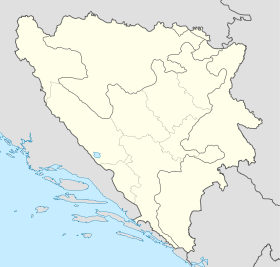
Bosnia and Herzegovina location map.svg
City locator 15.svg
Podlugovi

Podlugovi (en serbe cyrillique : Подлугови) est un village de Bosnie-Herzégovine. Il est situé dans la municipalité d'Ilijaš et dans le canton de Sarajevo, Fédération de Bosnie-et-Herzégovine. Au recensement de 1991, il comptait 1 448 habitants, dont une majorité de Serbes[1].

Sommaire

Démographie

Répartition de la population (1991)

Nationalité Nombre %
Serbes 1 185 81,83
Croates 123 8,49
Musulmans 70 4,83
Yougoslaves 50 3,45
Inconnus/autres 20 1,38[1]

En 1991, la communauté locale de Podlugovi comptait 1 773 habitants, répartis de la manière suivante[2] :

Nationalité Nombre %
Serbes 1 758 79,08
Croates 185 8,32
Musulmans 159 7,15
Yougoslaves 76 3,42
Inconnus/autres 45 2,02

Notes et références

  1. a et b (bs)(hr)(sr) Livre : Composition nationale de la population - Résultats de la République par municipalités et localités 1991, Bulletin statistique n°234, Publication de l'Institut national de statistique de Bosnie-Herzégovine, Sarajevo.
  2. (bs)(hr)(sr)[PDF] Recensement par communautés locales sur http://www.fzs.ba, Bosnie-Herzégovine - Fédération de Bosnie-et-Herzégovine - Institut fédéral de statistique. Consulté le 11 octobre 2010

Voir aussi

Articles connexes

Liens externes


Wikimedia Foundation. 2010.

Contenu soumis à la licence CC-BY-SA. Source : Article Podlugovi de Wikipédia en français (auteurs)

Игры ⚽ Поможем решить контрольную работу

Regardez d'autres dictionnaires:

  • Podlugovi — Podlugovi, Gemeinde in Bosnien, Kreis Sarajevo, an der Bosna und der Staatsbahnlinie Bosnisch Brod Sarajevo, Ausgangspunkt der Montanbahn P. Vares …   Meyers Großes Konversations-Lexikon

  • A1 (Bosnien und Herzegowina) — Vorlage:Infobox hochrangige Straße/Wartung/BA A Autoput A1 in Bosnien und Herzegowina …   Deutsch Wikipedia

  • Vlado Dijak — (born 1925 in Brezovo Polje near Brčko, Bosnia and Herzegovina died 1988 in Sarajevo, Bosnia and Herzegovina) was known as most unfamous writer in Yugoslavian classic literature.BiographyHe attended high school in Banja Luka, and at the age of 17 …   Wikipedia

  • Ilijaš — 43° 57′ 03″ N 18° 16′ 15″ E / 43.9508, 18.2708 …   Wikipédia en Français

  • Bosnisch-hercegovinische Eisenbahnen — Bosnisch hercegovinische Eisenbahnen. Die Geschichte der Eisenbahnen Bosniens und der Hercegovina beginnt mit ihrer im Jahre 1878 erfolgten Besetzung durch Österreich und Ungarn. Die traurige Lage des Landes vor diesem Zeitpunkte kennzeichnet am… …   Enzyklopädie des Eisenbahnwesens

  • Ilijaš — Infobox Settlement official name = Ilijaš settlement type = subdivision type = Country subdivision name = BIH timezone=CET utc offset=+1 map caption =Location of Ilijaš within Bosnia and Herzegovina. timezone DST= leader name = Nusret Mašić… …   Wikipedia

  • Misoča —   Village   Country  Bosnia and Herzegovina Canton …   Wikipedia

  • List of settlements in Bosnia and Herzegovina — This is a complete list of settlements in Bosnia and Herzegovina, as recorded by 1991 census, sorted by municipalities. Town of Sarajevo = Sarajevo Centar = • Mrkovići • Nahorevo• Poljine• Radava• Sarajevo (part of settlement)• Vića Sarajevo… …   Wikipedia

  • Baureihe 99.452 — Lenz Typ nn Baureihe 99.452 Nummerierung: RüKB 31nn–35nn 99 4521–4525 Anzahl: 5 Hersteller: Vulcan, Hanomag Baujahr(e): 1902–1911 Ausmusterung: 1963–1965 Bauart: B B n4vt …   Deutsch Wikipedia

  • Breza — Бреза …   Deutsch Wikipedia

Share the article and excerpts

Direct link
Do a right-click on the link above
and select “Copy Link”