Plymouth Breakwater
- Plymouth Breakwater
-
50°20′2.98″N 4°8′55.18″O / 50.3341611, -4.1486611

Le
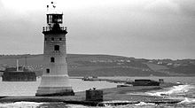
Plymouth breakwater vu depuis Kingsand montrant le phare de 1844 et le
Breakwater Fort en arrière plan.
Le Plymouth Breakwater, en français : brise-lame de Plymouth est un brise-lame en pierre de 1 560 mètres (1 706,04 yd) de long protégeant la Plymouth Sound et les points de mouillage se trouvant à l'intérieur. Il fait 13 mètres (42,65 pi) de large à son sommet et 65 mètres (213,2545935 pi) de large à sa base. Il se trouve par environ 10 mètres (32,81 pi) de fonds. Environ 4 millions de tonnes de pierre ont été nécessaires pour sa construction en 1812 pour un coût colossal pour l'époque de 1,5 million de £, soit l'équivalent de 74,7 millions £.
Références
Voir aussi
- Harbor of Refuge, une structure comparable à l'entrée de la baie du Delaware aux États-Unis, destiné principalement à un usage civil.
Liens externes
- (en) [1] Plymouth Breakwater
Wikimedia Foundation.
2010.
Contenu soumis à la licence CC-BY-SA. Source : Article Plymouth Breakwater de Wikipédia en français (auteurs)
Regardez d'autres dictionnaires:
Plymouth Breakwater — is a 1,560 metre/1,700 yard stone breakwater protecting Plymouth Sound and the anchorages therein. It is 13 metres/40 feet wide at the top and the base is 65 metres/200 feet. It lies in about 10 metres/30 feet of water. Around 4 million tons of… … Wikipedia
Plymouth Sound — Location map|United Kingdom label= background=white lat=50.343 long= 4.143 caption=Map of the UK showing the location of Plymouth Sound at 50.343°N, 4.143°W (grid reference mmukscaled|SX4751|100|SX4751)coord|50.343|N|4.143|W|type:landmark|display … Wikipedia
Plymouth — This article is about the city in England. For the Massachusetts town, see Plymouth, Massachusetts. For the car brand, see Plymouth (automobile). For other uses, see Plymouth (disambiguation). Plymouth City City of… … Wikipedia
Plymouth Harbor — is the name of a harbor located in Plymouth, Massachusetts, a town in the South Shore region of the state. It is part of the larger Plymouth Bay. Historically, Plymouth Harbor was the site of anchorage of the Mayflower where the Pilgrims… … Wikipedia
Plymouth [1] — Plymouth (spr. plímmöth), Stadt und Grafschaft an der Südwestküste Englands, am Plymouthsund (s. d.), einer Bai des Kanals (La Manche), in die der Tamar, Plym und kleinere Flüßchen münden. Lageplan von Plymouth. Das Ästuarium des Tamar … Meyers Großes Konversations-Lexikon
Plymouth — (spr. Plimmösh), 1) Stadt in der englischen Grafschaft Devon, am Einfluß des Tamers u. des Plym in den Kanal (La Manche), wo sie den Plymouthhafen, eine große Bai mit der befestigten Insel St. Nicolas, bilden; besteht aus dem eigentlichen P. u.… … Pierer's Universal-Lexikon
Breakwater (structure) — Breakwaters are structures constructed on coasts as part of coastal defence or to protect an anchorage from the effects of weather and longshore drift. Purposes of breakwatersOffshore breakwaters, also called bulkheads, reduce the intensity of… … Wikipedia
National Harbor of Refuge and Delaware Breakwater Harbor Historic District — U.S. National Register of Historic Places U.S. Historic district … Wikipedia
Railways in Plymouth — The network of railways in Plymouth, Devon, England, was developed by companies affiliated to two competing railways, the Great Western Railway and the London and South Western Railway.cite book | last = St John Thomas | first = David | title =… … Wikipedia
Palmerston Forts, Plymouth — The Palmerston Forts around Plymouth include:*Agaton Fort *Fort Austin *Fort Bovisand *Bowden Fort *Brownhill Battery *Cawsand Fort *Crownhill Fort *Drake s Island Battery *Fort Efford *Egg Buckland Keep *Ernesettle Fort *Forder Battery *Hawkins… … Wikipedia

