Murray Valley Highway

Murray Valley Highway
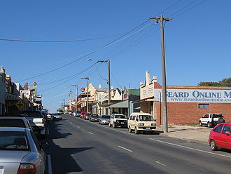
La Murray Valley Highway dans sa traversée de Rutherglen.

La Murray Valley Highway(Australian Alphanumeric State Route B400.svg/Australian Route 16.svg) est une route longue de 552 km orientée nord-ouest sud-est et qui suit la rive sud du fleuve Murray, au Victoria, en Australie.

L'extrémité ouest de la route se trouve à l'extrêmité du pont sur le Murray à Robinvale, prolongeant ainsi la route nationale 16. La route rejoint la Sturt Highway 2 km plus au nord. Autrefois, la Murray Valley Highway continuait plus vers l'ouest jusqu'à la Calder Highway à Hattah. L'extrémité est se trouve dans les contreforts de la Cordillère australienne à Corryong. La route continue vers l'est en traverseant la frontière vers la Nouvelle-Galles du Sud pour devenir l'Alpine Way.

La plus grande partie de la route est plate et assez rectiligne, passant le plus souvent au milieu des terres agricoles irriguées. Elle devient plus vallonnée et sinueuse à l'est de Wodonga, avec une partie plus montagneuse entre Tallangatta et Corryong.

Les grandes localités le long de la route sont Robinvale, Swan Hill, Kerang, Cohuna, Echuca, Nathalia, Strathmerton, Cobram, Yarrawonga, Rutherglen, Wodonga, Tallangatta et Corryong

Référence


Wikimedia Foundation. 2010.

Contenu soumis à la licence CC-BY-SA. Source : Article Murray Valley Highway de Wikipédia en français (auteurs)

Игры ⚽ Поможем сделать НИР

Regardez d'autres dictionnaires:

  • Murray Valley Highway — Murray Valley Highway …   Wikipedia

  • Murray Valley Highway — Verlauf Der Murray Valley Highway ist eine Fernverkehrsstraße in Victoria, Australien. Er verläuft über etwa 670 Kilometer in Nordwest Südost Richtung und folgt dabei dem Verlauf des Murray River und der Grenze zwischen New South Wales und… …   Deutsch Wikipedia

  • Murray valley — may refer to: the Murray River valley the electoral district of Murray Valley See also Murray Valley Highway. This disambiguation page lists articles associated with the same title. If an …   Wikipedia

  • Loddon Valley Highway — Infobox Australian Road road name = Loddon Valley Highway route route route photo = caption = Formerly length = 129 direction = North South start = finish = est = through = Serpentine, Eaglehawk route = B260 exits = The Loddon Valley Highway runs …   Wikipedia

  • Goulburn Valley Highway — Infobox Australian Road road name = Goulburn Valley Highway route route route photo = caption = length = 212 direction = Northeast Southeast start = finish = Lake Eildon, Eildon, Victoria est = through = Strathmerton, Shepparton, Nagambie,… …   Wikipedia

  • Plenty Valley Highway — Infobox Australian Road road name = Plenty Valley Highway route route route photo = caption = length = 9 direction = North South start = finish = est = through = Kingsbury, Reservoir East route = Metropolitan Ring Road Albert Street / Plenty Road …   Wikipedia

  • Murray Falls — Location Cardwell, Queensland Total height 30 m (98 ft) Murray Falls are located in Girramay National Park off the Bruce Highway between Tully and Cardwell, in Queensland, Australia. The falls drop 30 metres and may be viewed from a… …   Wikipedia

  • Hume Highway — Hume Freeway Proposed …   Wikipedia

  • Northern Highway, Victoria — Northern Highway Formerly …   Wikipedia

  • Mallee Highway — Formerly …   Wikipedia

Share the article and excerpts

Direct link
Do a right-click on the link above
and select “Copy Link”