Molong
Contenu soumis à la licence CC-BY-SA. Source : Article Molong de Wikipédia en français (auteurs)
Regardez d'autres dictionnaires:
Molong — Original name in latin Molong Name in other language Molong State code AU Continent/City Australia/Sydney longitude 33.09233 latitude 148.87002 altitude 532 Population 2136 Date 2011 10 22 … Cities with a population over 1000 database
Molong, New South Wales — Molong New South Wales The main shopping area of Molong, Bank Street … Wikipedia
Molong–Dubbo railway line — Molong Dubbo Line Legend … Wikipedia
Molong railway station — Molong is a closed railway station on the Broken Hill railway line in New South Wales, Australia. The station opened in 1885 is now closed to passenger services.[1] It was the terminus of the line between 1886 and 1893. [2] The station survives… … Wikipedia
Molong- Dubbo railway line, New South Wales — The Molong Dubbo railway line is a closed railway line in western New South Wales, Australia. It branched off of the Main Western railway line at Molong and paralleled the Main West line before rejoining it at Dubbo. The line was designed with… … Wikipedia
Molong — /ˈmoʊlɒŋ/ (say mohlong) noun a town in eastern central NSW, north west of Orange; limestone quarries. {? Australian Aboriginal} …
Electoral district of Molong — Molong was an electoral district of the Legislative Assembly in the Australian state of New South Wales, created in 1880 and named after and including Molong. In 1904, with the downsizing of the Legislative Assembly after Federation, it was… … Wikipedia
Main Western railway line, New South Wales — [Gauge: 1,435 mm (4 ft 8 1⁄2 in) Legend … Wikipedia
Lachlan Fold Belt — The Lachlan Fold Belt (LFB) or Lachlan Orogen is a geological subdivision of the east part of Australia. It is a zone of folded and faulted rocks of similar age. It dominates New South Wales and Victoria, also extending into Tasmania, the… … Wikipedia
Cumnock, New South Wales — Cumnock New South Wales … Wikipedia
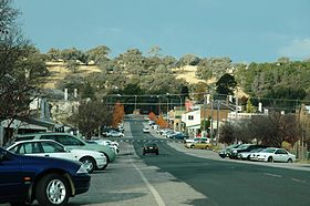 La grand-rue de Molong
 Australie
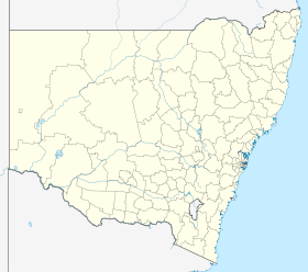
 Molong


