Maywand (district)
- Maywand (district)
-
 Pour les articles homonymes
,
voir Maywand.

Districts de la province de Kandahâr,
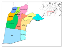
Maywand en orange
Maywand ou Maiwand est un district d'Afghanistan situé dans la partie occidentale de la province de Kandahâr. Les districts contigüs sont Ghorak au nord, Khakrez au nord-ouest ainsi que Panjwai à l'est et au sud. À l'ouest, le district est bordé par la province d'Helmand. La population du district était de 51 900 habitants en 2006. Le centre administratif du district est le village de Maiwand. La route principale reliant Lashkar Gah et Kandahar traverse le district.
Notes et références
Annexe
Articles connexes
Wikimedia Foundation.
2010.
Contenu soumis à la licence CC-BY-SA. Source : Article Maywand (district) de Wikipédia en français (auteurs)
Regardez d'autres dictionnaires:
Maywand District — A depiction of Maiwand during the 1878 British operations there. Maiwand District is situated in the western part of the Kandahar Province, Afghanistan. It borders Helmand Province to the west, Ghorak District to the north, Khakrez District to… … Wikipedia
Maywand District killings — Andrew Holmes, Michael Wagnon, Jeremy Morlock and Adam Winfield face murder charges. The Maywand District killings refer to the murder of three Afghan civilians perpetrated by a group of United States Army soldiers in 2010, during the War in… … Wikipedia
District d'Afghanistan — Districts de Afghanistan. Les provinces d Afghanistan sont divisés en Wolaswalei (Pashto: ولسوالۍ) ou districts. Le nombre de districts en Afghanistan a fluctué au fil des ans, avec de nouveaux districts créés par scission ou fusion des parties… … Wikipédia en Français
Maywand — Cette page d’homonymie répertorie les différents sujets et articles partageant un même nom. Toponymes Afghanistan Maywand ou Maiwand, district de la province de Kandah … Wikipédia en Français
Panjwaye District — Panjwai (also spelled Panjwaye, Panjwaii, Panjway or Panjwayi) is a district in Kandahar Province, Afghanistan. It is known as the birthplace of the Taliban. It is located about 35 kilometres (20 miles) west of Kandahar city. The district borders … Wikipedia
Ghorak District — is situated in the nortwestern part of Kandahar Province, Afghanistan. It borders Helmand Province to the West, Oruzgan Province and Naish District to the North, Khakrez District to the East and Maywand District to the South. The population is… … Wikipedia
Zhari District — Zhari is a new district in Kandahar Province, Afghanistan.Alternate spellings include Zheley (due to translation from Pashto) or Zharey. The district was created from territories taken from Maywand and Panjwai districts. The population is 76,000… … Wikipedia
Nawa-I-Barakzayi District — Not to be confused with Nawa District. Coordinates: 31°22′59″N 64°18′00″E / 31.383°N 64.3°E / 31.383; 64.3 … Wikipedia
Asadabad District — is one of 15 districts in Kunar Province, Afghanistan. It includes the city of Asadabad the district center, close the Kunar River. It is situated in the central part of the province. It has 12 big and small villages, which are surrounded by… … Wikipedia
Chahar Dara District — (also known as Char Dara, Chahar Darreh or Char Darreh) is one of the seven districts in Kunduz Province in northern Afghanistan. It is situated in the south west part of Kunduz Province and has borders with Qalay I Zal District to the north west … Wikipedia

