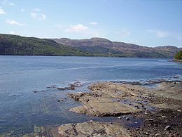
Loch Sunart
- Loch Sunart
-
Le loch Sunart (gaélique écossais: loch Shuaineart) est un loch de mer sur la cote ouest de l'Écosse. Le loch Sunart s'étend à l'ouest de la mer, bordée au nord par le district Ardnamurchan de Sunart et au sud par le district de Morvern. Un affluent du loch Sunart, le loch Teacuis, coule au sud-est dans le Morvern.
Avec 31 kilomètres, il est le plus long loch de mer dans le district de Highland. La profondeur maximale du lac est de 124 mètres à l'est de Càrna, à l'entrée du loch Teacuis. Deux grandes îles se trouvent dans le loch, Oronsay et Carna; Risga, elle se trouve entre les deux grandes îles, et Eilean Mor, se trouve à l'extrémité intérieure du loch en face de Beinn Resipol.
Depuis les années 1980, une très grande partie du loch est louée pour l'aquaculture et la pisciculture. A l'origine, seul le saumon était élevé, mais maintenant la pisciculture s'est un peu diversifiée.
Références
Liens internes
Wikimedia Foundation.
2010.
Contenu soumis à la licence CC-BY-SA. Source : Article Loch Sunart de Wikipédia en français (auteurs)
Regardez d'autres dictionnaires:
Loch Sunart — Sp Sùnarto įlanka Ap Loch Sunart angliškai Sp Lòch Sùnartas Ap Loch Suaineart geliškai (škotiškai) L Hebridų j., D. Britanija (Škotija) … Pasaulio vietovardžiai. Internetinė duomenų bazė
Oronsay, Loch Sunart — For other places with the same name, see Oronsay. Oronsay Location … Wikipedia
Sunart — Koordinaten 56° 42′ N, 5° 34′ W … Deutsch Wikipedia
Sunart — is a rural district and parish in south west Lochaber, Highland, Scotland, on the north shore of Loch Sunart. Today is often labelled as part of Ardnamurchan. The main village is Strontian, at the head of the loch, which is the location of… … Wikipedia
Loch class frigate — The Loch class was a class of anti submarine (A/S) frigate built for the Royal Navy and her allies during World War II. They were an innovative design based on the experience of 3 years of fighting in the Battle of the Atlantic and attendant… … Wikipedia
Loch Suaineart — Sp Sùnarto įlanka Ap Loch Sunart angliškai Sp Lòch Sùnartas Ap Loch Suaineart geliškai (škotiškai) L Hebridų j., D. Britanija (Škotija) … Pasaulio vietovardžiai. Internetinė duomenų bazė
Loch Raven Reservoir — Infobox lake lake name = Loch Raven Reservoir image lake = LochRaven.jpg caption lake = image bathymetry = caption bathymetry = location = Baltimore County, Maryland coords = coord|39|27|N|76|34|W|type:waterbody region:US|display=inline,title… … Wikipedia
Liste schottischer Lochs — Loch ist das schottisch gälische Wort für einen See oder eine Meeresbucht, einen Fjord (englisch Firth). Das Wort, lɔx, «loch» mit kehligem «ch» ausgesprochen, ist verwandt mit dem altirischen Lough, rekonstruierte indogermanische Wurzel… … Deutsch Wikipedia
Ardnamurchan — ARDNAMURCHAN, a parish, partly in the county of Argyll, and partly in the county of Inverness; comprising the quoad sacra districts of Aharacle and Strontian, and containing 5581 inhabitants. The present parish of Ardnamurchan, previously to… … A Topographical dictionary of Scotland
Morvern — MORVERN, a parish, in the district of Mull, county of Argyll, 18 miles (W. S. W.) from Strontian; containing 1774 inhabitants. This place, which anciently formed part of the territory of the celebrated Somerled, Thane of Argyll, takes its name … A Topographical dictionary of Scotland

 Royaume-Uni
 Écosse)


