Lisičići

Lisičići

43° 41′ 50″ N 17° 53′ 03″ E / 43.6972, 17.8842

Lisičići
Administration
Pays Drapeau de Bosnie-Herzégovine Bosnie-Herzégovine
Entité Drapeau de la Fédération de Bosnie-et-Herzégovine Fédération de Bosnie-et-Herzégovine
Canton Herzégovine-Neretva
Municipalité Konjic
Géographie
Coordonnées 43° 41′ 50″ Nord
       17° 53′ 03″ Est
/ 43.6972, 17.8842
Démographie
Population 238 hab. (1991)
Localisation
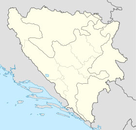
Bosnia and Herzegovina location map.svg
City locator 15.svg
Lisičići

Lisičići (en cyrillique : Лисичићи) est un village de Bosnie-Herzégovine. Il est situé dans la municipalité de Konjic et dans le canton d'Herzégovine-Neretva, Fédération de Bosnie-et-Herzégovine. Au recensement de 1991, il comptait 238 habitants, dont une majorité de Musulmans (Bosniaques)[1].

Lisičići est situé sur la rive droite de la Neretva.

Sommaire

Démographie

Répartition de la population (1991)

Nationalité Nombre %
Musulmans 231 97,06
Croates 5 2,10
Yougoslaves 1 0,42
Inconnus/autres 1 0,42[1]

En 1991, la communauté locale de Lisičići comptait 507 habitants, répartis de la manière suivante[2] :

Nationalité Nombre %
Musulmans 358 70,61
Croates 144 28,40
Serbes 3 0,59
Yougoslaves 1 0,20
Inconnus/autres 1 0,20

Notes et références

  1. a et b (bs)(hr)(sr) Livre : Composition nationale de la population - Résultats de la République par municipalités et localités 1991, Bulletin statistique n°234, Publication de l'Institut national de statistique de Bosnie-Herzégovine, Sarajevo.
  2. (bs)(hr)(sr)[PDF] Recensement par communautés locales sur http://www.fzs.ba, Bosnie-Herzégovine - Fédération de Bosnie-et-Herzégovine - Institut fédéral de statistique. Consulté le 11 octobre 2010

Voir aussi

Articles connexes

Liens externes


Wikimedia Foundation. 2010.

Contenu soumis à la licence CC-BY-SA. Source : Article Lisičići de Wikipédia en français (auteurs)

Игры ⚽ Нужна курсовая?

Regardez d'autres dictionnaires:

  • Holiday home Lisicic Croatia — (Lisičići,Хорватия) Категория отеля: Адрес: 23420 Lisičići, Хорватия …   Каталог отелей

  • Konjic (Bosnie-Herzégovine) — Pour les articles homonymes, voir Konjic. 43° 39′ 00″ N 17° 58′ 01″ E …   Wikipédia en Français

  • Cardium Pottery — Cardium Pottery, Printed Cardium Pottery or Cardial Ware is a Neolithic decorative style that gets its name from the imprinting of the clay with the shell of the Cardium edulis , a marine mollusk. The alternative names of Printed Cardium Pottery… …   Wikipedia

  • Early history of Bosnia and Herzegovina — Within the boundaries of today’s Bosnia and Herzegovina, there have been many layers of prehistoric cultures whose creation and disappearance are linked to migrations of unidentified ethnic groups. PrehistoryThe Paleolithic in B H is marked by… …   Wikipedia

  • Art of Bosnia and Herzegovina — Ancient Heritage Prehistory there have been many layers of prehistory cultures and their creation and disappearance is linked to migrations of unidentified ethnic groups. Paleolithic in B H is market with oldest monument of Paleolithic in… …   Wikipedia

  • List of settlements in Bosnia and Herzegovina — This is a complete list of settlements in Bosnia and Herzegovina, as recorded by 1991 census, sorted by municipalities. Town of Sarajevo = Sarajevo Centar = • Mrkovići • Nahorevo• Poljine• Radava• Sarajevo (part of settlement)• Vića Sarajevo… …   Wikipedia

  • List of settlements in the Federation of Bosnia and Herzegovina/L — La Lađanica, Laleta, Le Lendava, Li Lisičići, Livno, Lo Lokva, Lokve, Lokve, Lu Lug, Luka, Lukarice, Lukavac, Lukomir, Lukšije …   Wikipedia

  • Konjic — Коњиц …   Deutsch Wikipedia

  • Lukomir —  Pour l’article homonyme, voir Lukomir (Žitorađa).  43° 38′ 14″ N 18° 11′ 00″ E …   Wikipédia en Français

  • Cerámica cardial — Horizonte con cerámicas cardiales Localización geográfica aproximada. Datos Cronología: VI milenio adC V milenio adC Localización: Costas del Mediterráneo occ …   Wikipedia Español

Share the article and excerpts

Direct link
Do a right-click on the link above
and select “Copy Link”