Leopoldsdorf
Contenu soumis à la licence CC-BY-SA. Source : Article Leopoldsdorf de Wikipédia en français (auteurs)
Regardez d'autres dictionnaires:
Leopoldsdorf — ist der Name folgender Orte: Leopoldsdorf im Marchfelde, eine Gemeinde in Niederösterreich Leopoldsdorf (Bezirk Wien Umgebung), eine Gemeinde in Niederösterreich Klausen Leopoldsdorf, eine Gemeinde in Niederösterreich Leopoldsdorf (Gemeinde… … Deutsch Wikipedia
Leopoldsdorf — Infobox Ort in Österreich Art = Marktgemeinde Name = Leopoldsdorf Wappen = lat deg = 48 | lat min = 07 | lat sec = 00 lon deg = 16 | lon min = 23 | lon sec = 00 Bundesland = Niederösterreich Bezirk = Wien Umgebung Höhe = 161 Fläche = 6.95… … Wikipedia
Leopoldsdorf — Original name in latin Leopoldsdorf Name in other language State code AT Continent/City Europe/Vienna longitude 48.11557 latitude 16.39126 altitude 185 Population 0 Date 2011 07 31 … Cities with a population over 1000 database
Leopoldsdorf im Marchfelde — Leopoldsdorf im Marchfelde … Deutsch Wikipedia
Leopoldsdorf (Bezirk Wien-Umgebung) — Leopoldsdorf … Deutsch Wikipedia
Leopoldsdorf (Gemeinde Reingers) — Leopoldsdorf ist eine Katastralgemeinde im nördlichen Waldviertel, die zur Gemeinde Reingers in Österreich gehört. Leopoldsdorf ist mit 250 Einwohnern die größte Ortschaft der Gemeinde Reingers und liegt auf etwa 600 m ü. A..… … Deutsch Wikipedia
Leopoldsdorf im Marchfelde — Infobox Town AT name=Leopoldsdorf im Marchfelde name local= image coa = 120px Wappen Leopoldsdorf.jpg state = Lower Austria regbzk = district = Gänserndorf population =2392 population as of = 2001 population ref = pop dens = area = 28.95… … Wikipedia
Leopoldsdorf im Marchfelde — 48° 13′ 27″ N 16° 41′ 23″ E / 48.2241, 16.6896 … Wikipédia en Français
Leopoldsdorf im Marchfelde — Original name in latin Leopoldsdorf im Marchfelde Name in other language Leopol dsdorf im Markhfel de, Leopoldsdorf, Леопольдсдорф им Мархфельде State code AT Continent/City Europe/Vienna longitude 48.22261 latitude 16.68858 altitude 147… … Cities with a population over 1000 database
Klausen-Leopoldsdorf — Klausen Leopoldsdorf … Deutsch Wikipedia

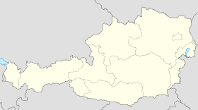
 Autriche
 Basse-Autriche
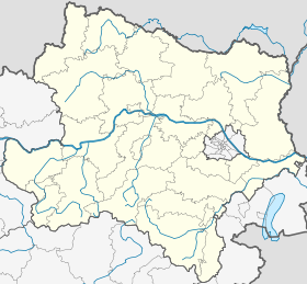

 Leopoldsdorf


