Kraburi
- Kraburi
-
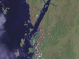
La Kraburi ou Pak Chan est un fleuve frontalier de la Birmanie et de la Thaïlande.
Géographie
Il prend sa source dans les montagnes de l'isthme de Kra et coule vers le sud-ouest. Il se jette dans la Mer d'Andaman au niveau de la ville thaïlandaise de Ranong (et de Victoria point pour la Birmanie).
Son estuaire large de presque 6 km abrite la dernière mangrove de Thaïlande. Une partie est couverte par le Parc national de Lam Nam Kraburi, tandis que la Réserve de la biosphère de Ranong et le Site Ramsar de Laemson se trouvent plus au sud.
Voir aussi
Liens externes
Notes et références
Catégories :
- Cours d'eau de Birmanie
- Cours d'eau de Thaïlande
- Cours d'eau frontalier
Wikimedia Foundation.
2010.
Contenu soumis à la licence CC-BY-SA. Source : Article Kraburi de Wikipédia en français (auteurs)
Regardez d'autres dictionnaires:
Kraburi — oder Kra Buri steht für: Kraburi (Fluss) in Südthailand Amphoe Kra Buri, Landkreis in Südthailand Diese Seite ist eine Begriffsklärung zur Unterscheidung mehrerer mit demselben Wort bezeichneter Begriffe … Deutsch Wikipedia
Kraburi (Fluss) — Maenam Kraburi Satellitenfoto der MündungVorlage:Infobox Fluss/KARTE fehlt Daten … Deutsch Wikipedia
Kraburi River — The Kraburi River (also Kra or Pakchan River) is the boundary river between Thailand and Myanmar at the Kra Isthmus of the Malay Peninsula. The river flows into the Andaman Sea near the Thai town Ranong and Kawthaung (Victoria Point),… … Wikipedia
Amphoe Kra Buri — Kra Buri กระบุรี Provinz: Ranong Fläche: 783,0 km² Einwohner: 44.808 (2005) Bev.dichte: 57,2 E./km² PLZ: 85110 … Deutsch Wikipedia
Amphoe La-un — La un ละอุ่น Provinz: Ranong Fläche: 748,5 km² Einwohner: 12.506 (2005) Bev.dichte: 16,7 E./km² PLZ: 85130 … Deutsch Wikipedia
Ranong — Mueang Ranong เมืองระนอง Provinz: Ranong Fläche: 713,7 km² Einwohner: 90.569 (2005) Bev.dichte: 126,9 E./km² PLZ: 85000 … Deutsch Wikipedia
Royal Thai Navy — กองทัพเรือ, ราชนาวี (RTGS: Kongthap Ruea, Ratcha Navy) Emblem of the Royal Thai Navy Active 1900 … Wikipedia
Amphoe Kra Buri — Infobox Amphoe name=Kra Buri thai=กระบุรี province=Ranong coordinates=coord|10|25|54|N|98|47|18|E|type:adm2nd region:TH area=783.0 population=44,808 population as of=2005 density=57.2 postal code=85110 geocode=8504Kra Buri ( th. กระบุรี) is the… … Wikipedia
List of national parks of Thailand — Haeo Suwat waterfall in Khao Yai National Park, Thailand s first national park, designated in 1961. National parks in Thailand (Thai: อุทยานแห่งชาติทางบก) are defined as an area of least ten square kilometres that contains natural resources of… … Wikipedia
Liste der Flüsse in Asien — Die Liste der asiatischen Flüsse ist eine nach Staaten sortierte Aufzählung von Flüssen auf dem asiatischen Kontinent. Siehe auch Liste der längsten Flüsse der Erde. Inhaltsverzeichnis 1 Flüsse in Asien … Deutsch Wikipedia
 Birmanie
 Thaïlande