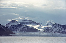
- Kongsfjorden
-
Kongsfjorden (Kongsfjord ou Fjord du Roi) est un grau situé dans le Spitzberg occidental, une île qui fait partie de l'archipel du Svalbard norvégien dans l'océan Arctique.
Sommaire
Géographie
L'entrée du fjord est de 26 km de long et sa largeur varie de 6 à 14 km. Deux glaciers bordent le chenal, Kronebreen et Kongsvegen, à la tête du fjord[1]. La ville minière de Ny-Ålesund est située sur la rive sud et est l'un des 4 établissements permanents sur le Spitzberg. C'est aussi un arrêt populaire pour croisière, mais la communauté scientifique s'inquiète que le tourisme pourrait causer des interférences avec les dispositifs scientifiques sensibles[2].
Kongsfjorden s'appelait à l'origine Deer Sound par Jonas Poole (1610), et était connue comme telle par les baleiniers anglais, au moins jusqu'en 1658. Giles et Rep furent les premiers à le nommer Koninks Bay. William Scoresby (1820), reprend cette erreur en la désignant Kings Bay pendant qu'il se déplace de Deer Sound à une baie dans le nord du fjord. Les cartographes modernes ont simplement répété cette erreur.
Voir aussi
Articles connexes
Liens externes
Bibliographie
- (en) Sir William Martin Conway, No Man’s Land: A History of Spitsbergen from Its Discovery in 1596 to the Beginning of the Scientific Exploration of the Country, Presse universitaire de Cambridge, 1906 (ISBN 1437265774) (OCLC 639489)
- (en) William Scoresby, An account of the Arctic regions with a history and description of the northern whale-fishery, A. Constable & Co, 1820 (OCLC 2932912)
Notes
- (en) Norwegian Kongsfjorden - Encyclopædia Britannica
- (en) Scott Polar Research Institute
Catégories :- Fjord du Svalbard
- Spitzberg
Wikimedia Foundation. 2010.

