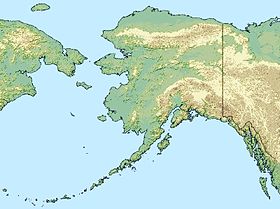
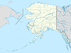
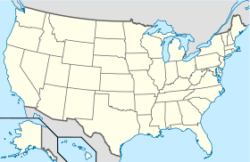
Koliganek (Alaska)
- Koliganek (Alaska)
-
59° 43′ 44″ N 157° 16′ 38″ W / 59.728889, -157.277222
Koliganek est une localité d'Alaska aux États-Unis dans la Région de recensement de Dillingham. En 2010, il y avait 209 habitants.
Situation - climat
Elle est située sur la rive gauche de la rivière Nushagak à 65 milles (105 km) au nord-est de Dillingham.
La moyenne des température va de 37 degrés Fahrenheit (3 °C) à 66 degrés Fahrenheit (19 °C) en juillet et de 4 degrés Fahrenheit (-16 °C) à 30 degrés Fahrenheit (-1 °C) en janvier.
Histoire
C'est un village Eskimo, qui s'appelait Kalignak la première fois où il a été référencé, en 1880. Depuis, il s'est déplacé 4 milles (6 km) en aval de la rivière.
Économie
L'école et l'organisation administrative du village procurent la majorité des emplois. Toutefois, la plupart des habitants pratiquent parallèlement une économie de subsistance. En plus de l'école, il existe un dispensaire, deux magasins d'alimentation générale, et un dépôt de carburant.
Article connexe
Sources et références
Wikimedia Foundation.
2010.
Contenu soumis à la licence CC-BY-SA. Source : Article Koliganek (Alaska) de Wikipédia en français (auteurs)
Regardez d'autres dictionnaires:
Koliganek, Alaska — Infobox Settlement official name = Koliganek, Alaska settlement type = CDP nickname = motto = imagesize = image caption = image mapsize = 250px map caption = Location of Koliganek, Alaska mapsize1 = map caption1 = subdivision type = Country… … Wikipedia
Koliganek (Alaska) — Koliganek Lugar designado por el censo de los Estados Unidos … Wikipedia Español
Koliganek Airport — IATA: KGK – ICAO: PAJZ – FAA LID: JZZ Summary … Wikipedia
Koliganek — Koliganek … Deutsch Wikipedia
Alaska locations by per capita income — Alaska has the fourteenth highest per capita income in the United States of America, at $22,660 (2000). Its personal per capita income is $33,568 (2003), the twelfth highest in the country. Its median household income is $51,571 (2000), ranked… … Wikipedia
Koliganek — Koliganek, AK U.S. Census Designated Place in Alaska Population (2000): 182 Housing Units (2000): 77 Land area (2000): 12.461114 sq. miles (32.274136 sq. km) Water area (2000): 0.054091 sq. miles (0.140095 sq. km) Total area (2000): 12.515205 sq … StarDict's U.S. Gazetteer Places
Koliganek, AK — U.S. Census Designated Place in Alaska Population (2000): 182 Housing Units (2000): 77 Land area (2000): 12.461114 sq. miles (32.274136 sq. km) Water area (2000): 0.054091 sq. miles (0.140095 sq. km) Total area (2000): 12.515205 sq. miles… … StarDict's U.S. Gazetteer Places
List of Alaska Native tribal entities — rThis is a list of Alaska Native tribal entities which are recognized by the United States Bureau of Indian Affairs. For related lists, see the List of Indian reservations in the United States, List of Native American Tribal Entities (federally… … Wikipedia
Dillingham Census Area, Alaska — Dillingham Census Area is a census area located in the state of Alaska, United States. As of the 2000 census, the population was 4,922. It is part of the unorganized borough and therefore has no borough seat. Its largest community by far is the… … Wikipedia
Dillingham, Alaska — Dillingham redirects here. For the Hawaii industrialist, see Benjamin Dillingham. Dillingham, Alaska Curyuk City Dillingham, Alaska w … Wikipedia
 États-Unis
 Alaska