Kirup
Contenu soumis à la licence CC-BY-SA. Source : Article Kirup de Wikipédia en français (auteurs)
Regardez d'autres dictionnaires:
Kirup, Western Australia — Infobox Australian Place | type = town name = Kirup state = Western Australia imagesize= 250px caption = Kirup Tavern and Deli lga = Shire of Donnybrook Balingup postcode = 6251 est = 1901 pop = 324 (2006 Census) [Census 2006 AUS|id=SSC54361|name … Wikipedia
Nelson Land District — For the land district in New Zealand, see Land Districts of New Zealand. Nelson Western Australia Location in Western Australia … Wikipedia
Donnybrook, Western Australia — Donnybrook Western Australia Donnybrook Main Street … Wikipedia
Mullalyup, Western Australia — Mullalyup Western Australia … Wikipedia
Shire of Donnybrook-Balingup — This article is about a local government area. For the town, see Donnybrook, Western Australia. Shire of Donnybrook Balingup Western Australia … Wikipedia
Great Walk Networking — Infobox Non profit Non profit name = Great Walk Networking Non profit Non profit type = Conservation founded date = 1988 location = Western Australia origins = The Great Walk, a 650 km supported bushwalk to raise awareness of logging old growth… … Wikipedia
Margaret River, Western Australia — Margaret River Western Australia Town centre … Wikipedia
Collie, Western Australia — Collie Western Australia Main street of Collie … Wikipedia
List of Western Australian towns — This is a list of Towns of Western Australia: A*Abbotts *Agnew *Ajana *Albany *Aldersyde *Allanson *Amery *Ardath *Arrino *Augusta *Auski *Austin Abandoned *AustralindB*Bassendean *Baandee *Babakin *Badgebup *Badgingarra *Badjaling *Bakers Hill… … Wikipedia
Capel, Western Australia — Capel Western Australia … Wikipedia
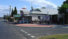 La taverne de Kirup
 Australie
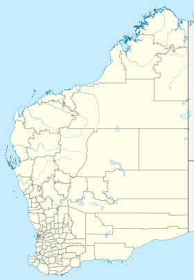
 Kirup
Kirup


