Harichovce
- Harichovce
-
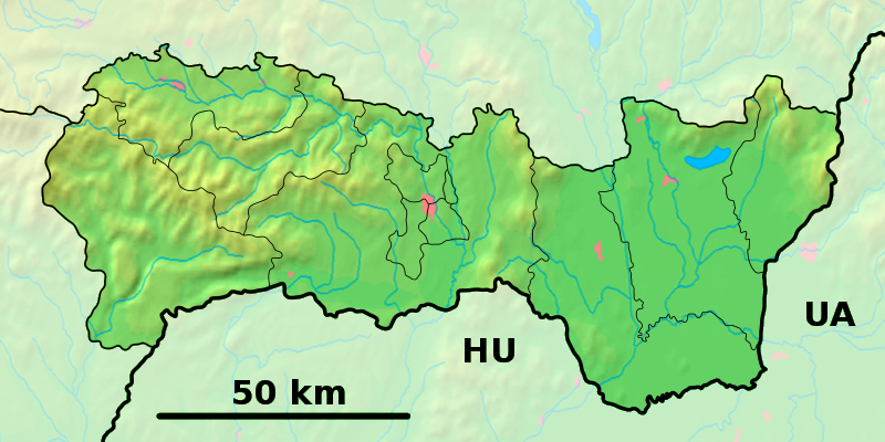
Harichovce (allemand : Palmsdorf) est un village de Slovaquie situé dans la région de Košice.
Histoire
Première mention écrite du village en 1268.
Notes et références
Catégories :
- Village de Slovaquie
- Village et ville du district de Spišska Nová Ves
Wikimedia Foundation.
2010.
Contenu soumis à la licence CC-BY-SA. Source : Article Harichovce de Wikipédia en français (auteurs)
Regardez d'autres dictionnaires:
Harichovce — Wappen Karte … Deutsch Wikipedia
Harichovce — is a village and municipality in the Spišská Nová Ves District in the Košice Region of central eastern Slovakia.HistoryIn historical records the village was first mentioned in 1268.GeographyThe village lies at an altitude of 446 metres and covers … Wikipedia
District de Spišská Nová Ves — Spišská Nová Ves Informations Pays … Wikipédia en Français
Košice Region — Geobox | Region name = Košice other name = category = Region image caption = image caption = symbol = symbol type = Coat of arms etymology = official name = motto = nickname = country = Slovakia country state = region = district = commune =… … Wikipedia
Spišská Nová Ves District — District Country Slovakia Reg … Wikipedia
List of municipalities and towns in Slovakia — Slovakia This is a comprehensive list of municipalities and towns in Slovakia. For lists of towns and municipalities sorted by Regions see the individual articles on Regions. For an outdated list of towns only in Slovakia see also List of towns… … Wikipedia
Danišovce — Location of Spisska District in the Košice Region Monument in the centre of t … Wikipedia
Chrasť nad Hornádom — Location of Spisska District in the Košice Region Chrasť nad Hornádom is a village and municipality in the Spišská Nová Ves District in the Košice Region of central eastern Slovakia. History In historical records the village was first menti … Wikipedia
Markušovce — Coordinates: 48°55′N 20°38′E / 48.917°N 20.633°E / 48.917; 20.633 … Wikipedia
Matejovce nad Hornádom — Location of Spisska District in the Košice Region Matejovce nad Hornádom is a village and municipality in the Spišská Nová Ves District in the Košice Region of central eastern Slovakia. History In historical records the village was first me … Wikipedia
 Slovaquie
 Harichovce