Glen Affric

Glen Affric

57° 14′ 09″ N 5° 09′ 12″ W / 57.23596, -5.15327

Glen Affric

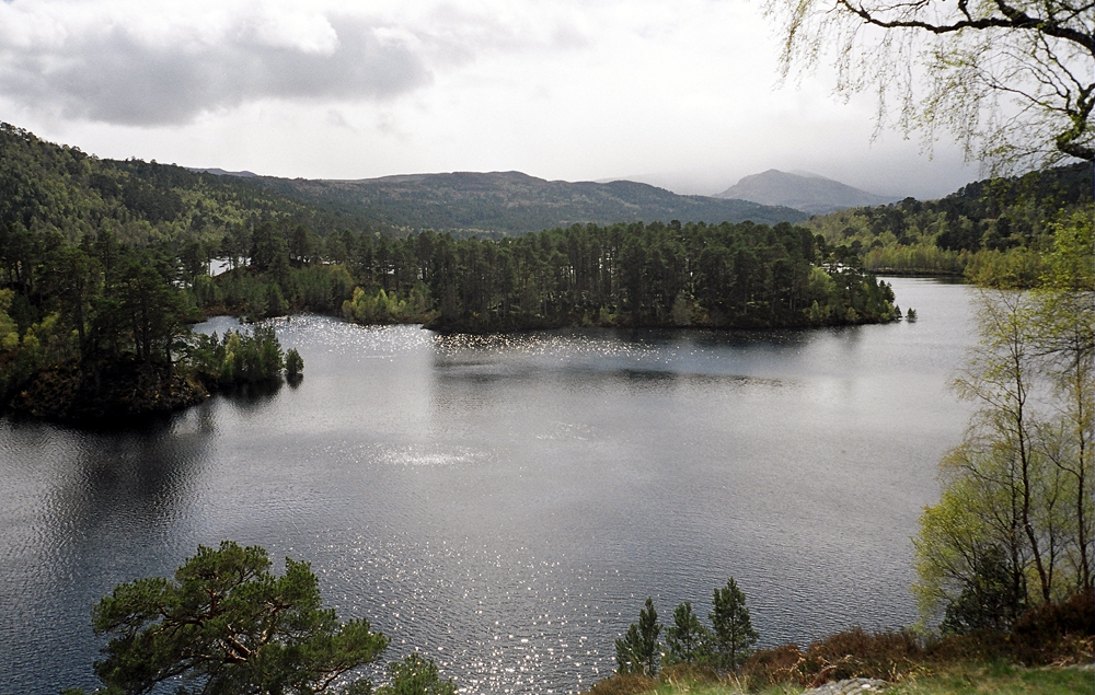
Glen Affric (en gaélique écossais : Gleann Afaraig) est un glen au sud-ouest du village de Cannich dans les Highland en Écosse, à l'ouest de Loch Ness. La rivière Affric le suit sur toute sa longueur, traversant Loch Affric et Loch Beinn a' Mheadhoin (Loch Benevean).

Il fut un temps une partie des terres du clan Chisholm.

La région forme une réserve de forêt calédonienne, une National Scenic Area et une réserve naturelle nationale. Souvent décrit comme le plus beau glen d'Écosse, on y trouve les plus anciennes traces de la forêt calédonienne, ainsi que des lochs, des landes et des montagnes.

Affric Lodge, maison construite pour la chasse, est située sur une péninsule à Loch Affric, tandis que l'hôtel de la Scottish Youth Hostels Association est un peu plus loin que le glen à Alltbeithe.

Le glen est intégré au plan de production d'énergie hydroélectrique Affric/Beauly, géré par le North of Scotland Hydro-Electric Board. Loch Mullardoch, dans le voisin Glen Cannich, est condamné, et un tunnel de 5 km amène l'eau à Loch Benevean, qui a également été condamné. À partir de là, un autre tunnel achemine l'eau à la station de Fasnakyle près de Cannich.

La dernière piste de l'album Stepping into the Dark du musicien Chris Watson porte le titre The Forest Path. Meallan Ne Ceardaich, Glen Affric, Scotland et est enregistrée Glen Affric.

Liens externes


Wikimedia Foundation. 2010.

Contenu soumis à la licence CC-BY-SA. Source : Article Glen Affric de Wikipédia en français (auteurs)

Игры ⚽ Поможем решить контрольную работу

Regardez d'autres dictionnaires:

  • Glen Affric — (Scottish Gaelic: Gleann Afaraig ) is a glen south west of the village of Cannich in the Highland region of Scotland, some 15 miles to the west of Loch Ness. The River Affric runs along its length, passing through Loch Affric and Loch Beinn a… …   Wikipedia

  • Glen Affric — Der Glen Affric ist ein ca. 30 km langes Tal („Glen“) in den schottischen Northwest Highlands. Es befindet sich etwa 24 km westlich von Loch Ness. Durch das Tal fließt der Fluss Affric. Das Tal gehörte ursprünglich zum Gebiet des Clans… …   Deutsch Wikipedia

  • Glen Affric — Sp Ãfriko slėnis Ap Glen Affric angliškai Sp Gleñ Ãfrikas Ap Gleann Afraig geliškai (škotiškai) L D. Britanijoje (Škotijoje) …   Pasaulio vietovardžiai. Internetinė duomenų bazė

  • Dog Falls, Glen Affric — Dog Falls (Gaelic: Eas a Choin) is a series of waterfalls on the River Affric, in Glen Affric in the Highlands of Scotland. The falls are within the Glen Affric National Nature Reserve, managed by Forestry Commission Scotland. There are several… …   Wikipedia

  • Affric-Beauly hydro-electric power scheme — The Affric / Beauly hydro electric power scheme for the generation of hydro electric power is located in the western Highlands of Scotland. It is based around Glen Stratharrar, Glen Cannich and Glen Affric, and Strathglass further downstream.The… …   Wikipedia

  • Glen Strathfarrar — is a glen in the Highland region of Scotland, near Loch Ness. The River Farrar runs through the glen. [ [http://www.glenaffric.org/strathfarrar.html Glen Strathfarrar] . GlenAffric.org. Retrieved 13 March 2007.] The Glen is part of the Affric… …   Wikipedia

  • Loch Affric — Geographische Lage Highland, Schottland Zuflüsse Affric …   Deutsch Wikipedia

  • Mam Sodhail — seen from Càrn Eige, 1 km to the NE. Elevation 1,181 m (3 …   Wikipedia

  • Sgurr nan Ceathramhnan — Infobox Mountain Name = Sgurr nan Ceathreamhnan Photo = Sgurr nan Ceathreamhnan from Mam Sodhail.jpg Caption = Sgurr nan Ceathreamhnan from Mam Sodhail, 5 km to the NE. The Kintail hills are in the background Elevation = 1151 m (3776 ft) Location …   Wikipedia

  • Ciste Dhubh — seen from the Corbett Am Bàthach, three km to the south. Elevation …   Wikipedia

Share the article and excerpts

Direct link
Do a right-click on the link above
and select “Copy Link”