Division de Kumaon
- Division de Kumaon
-
| Division de Kumaon |
| Capitale : |
Nainital |
| Superficie : |
21 056 km² |
| Population : |
4 668 329 hab.(2001) |
| Densité : |
222 hab/km² |
| Carte |
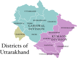 |
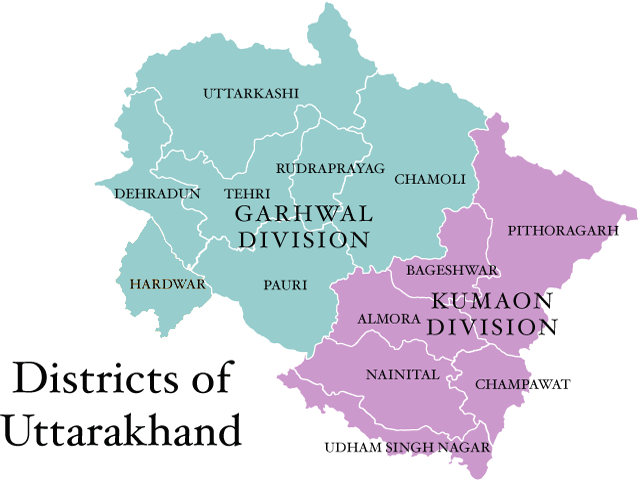
La Division de Kumaon est l'une des 2 divisions administratives de l'État indien de l'Uttarakhand (l'autre étant le Garhwal).
Il est constitué de 6 districts :
- Pithoragarh
- Bageshwar
- Almora
- Champawat
- Nainital
- Udham Singh Nagar
Wikimedia Foundation.
2010.
Contenu soumis à la licence CC-BY-SA. Source : Article Division de Kumaon de Wikipédia en français (auteurs)
Regardez d'autres dictionnaires:
Kumaon division — Kumaon (or Kumaun) is one of the two regions and administrative divisions of Uttarakhand, a mountainous state of northern India, the other being Garhwal. It includes the districts of Almora, Bageshwar, Champawat, Nainital, Pithoragarh, and Udham… … Wikipedia
Kumaon — may refer to: * Kumaon Division * Kumaon District * Kumaon Regiment * Kumaun … Wikipedia
Kumaon — (Kamaon), Division der britisch ind. Nordwestprovinzen, liegt ganz im Himalajagebirge, grenzt im N. an Tibet, im O. an Nepal und hat 32,213 qkm Fläche mit (1901) 1,207,030 Einw. (1,118,118 Hindu, 84,450 Mohammedaner). Einen Teil des Landes bilden … Meyers Großes Konversations-Lexikon
Kumaon — Kumāon (Kamaun), Division der indobrit. Vereinigten Provinzen (Nordwestprovinzen: jetzt Agra), 35.593 qkm, (1901) 1.202.130 E.; Hauptstadt Almora … Kleines Konversations-Lexikon
Division de Garhwal — 30° 30′ N 78° 30′ E / 30.5, 78.5 … Wikipédia en Français
Garhwal division — Garhwal, or Gurwal ( hi. गढ़वाल; IPA2|ɡəɽʱʋa:l, is a region and administrative division of Uttarakhand state, India, lying in the Himalayas. It is bounded on the north by Tibet, on the east by Kumaon region, on the south by Uttar Pradesh state,… … Wikipedia
60th (2/2nd London) Division — Infobox Military Unit unit name= 60th (2/2nd London) Division caption= dates= World War I August 31, 1914 May 31, 1919 country= United Kingdom allegiance= branch= Territorial Force type=Infantry role= size= command structure= current commander=… … Wikipedia
Uttarakhand — 30° 20′ N 78° 04′ E / 30.33, 78.06 … Wikipédia en Français
Provincias Unidas de Agra y Oudh — Mapa de las Provincias Unidas (1903). Las Provincias Unidas de Agra y Oudh, conocidas principalmente como las Provincias Unidas, fue una provincia de la India Británica, que existió entre 1902 y 1947. Desde 1835 hasta 1902, la provincia fue… … Wikipedia Español
Pantnagar — Ajouter une image Administration Pays Inde État et territoire Uttarakhand District … Wikipédia en Français