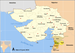
- District de Valsad
-
District de Valsad 
Administration Pays  Inde
IndeType District État Gujarat Siège administratif Valsad Géographie Superficie 3 034 km2 Population Population 1 410 680 hab. (2001) Densité 465 hab./km2 Le district de Valsad est un district de l'état du Gujerat en Inde.

États du Gujarat
Gouverneurs | Chief Ministers | DistrictsDivisions administratives :
Tehsil
District
• Capitales : Gandhinagar • Grandes villes : Ahmedabad | Surat | Vadodara | Rajkot | Jamnagar | Bhavnagar • Districts : Ahmedabad | Amreli | Anand | Banaskantha | Bharuch | Bhavnagar | Dahod | Dang | Gandhinagar | Jamnagar | Junagadh | Kheda | Kutch | Mehsana | Narmada | Navsari | Panchmahal | Patan | Porbandar | Rajkot | Sabarkantha | Surat | Surendranagar | Tapi | Vadodara | Valsad • Histoire • Personnalité • Ville
Wikimedia Foundation. 2010.
