Columbia Basin Project
- Columbia Basin Project
-

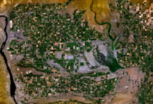
Photo satellite de la zone irriguée entourant le
lac Potholes.
Le Columbia Basin Project (CBP) est un réseau d'irrigation rendu possible par le barrage de Grand Coulee, dans le centre de l'État de Washington, aux États-Unis.
C'est un des plus grands projets de traitement de l'eau pour l'agriculture aux États-Unis, approvisionnement l'irrigation à plus de 2 700 km2 des 4 500 km2 que compte la zone du projet initiale et toujours ouvert à un éventuel élargissement du système.
L'eau pompée du fleuve Columbia transite par des canaux, puis est stockée dans un certain nombre de lacs de barrage (comme le lac Moses ou le lac Potholes), avant d'alimenter un réseau secondaire de canaux d'irrigation.
Wikimedia Foundation.
2010.
Contenu soumis à la licence CC-BY-SA. Source : Article Columbia Basin Project de Wikipédia en français (auteurs)
Regardez d'autres dictionnaires:
Columbia Basin Project — The Columbia Basin Irrigation Project The Columbia Basin Project (or CBP) in Central Washington, USA, is the irrigation network that the Grand Coulee Dam makes possible. It is the largest water reclamation project in the United States, supplying… … Wikipedia
Columbia Basin — The Columbia Basin The Columbia Basin, the drainage basin of the Columbia River, occupies a large area–about 673,396 square kilometres (260,000 sq mi) of the Pacific Northwest region of North America.[1] In common usage, the term often… … Wikipedia
Columbia Basin Trust — The Columbia Basin Trust was created by the Columbia Basin Trust Act (British Columbia)[1] in 1995 to benefit the region most adversely affected by the Columbia River Treaty (CRT), in the Canadian province of British Columbia. The CRT, ratified… … Wikipedia
Columbia River — Der Columbia RiverVorlage:Infobox Fluss/KARTE fehlt Daten … Deutsch Wikipedia
Columbia Rediviva — Équipage 16 à 30 marins Gréement sloop Débuts 1773 Longueur hors tout … Wikipédia en Français
Columbia National Wildlife Refuge — IUCN Category IV (Habitat/Species Management Area) … Wikipedia
Columbia Valley (AVA) — Columbia Valley Désignation(s) Columbia Valley Appellation(s) principale(s) Columbia Valley Type d appellation(s) AVA Reconnue depuis 1984 … Wikipédia en Français
Columbia River — Coordinates: 46°14′39″N 124°3′29″W / 46.24417°N 124.05806°W / 46.24417; 124.05806 … Wikipedia
Columbia (fleuve) — Pour les articles homonymes, voir Columbia. Cet article possède un homophone, voir Colombia. Columbia (Columbia River, Wimahl, Nch’i Wàna) … Wikipédia en Français
Columbia River Treaty — The Duncan Dam was required under the Treaty, and was completed in 1967. It has no powerhouse and remains purely a storage project … Wikipedia
 Photo satellite de la zone irriguée entourant le lac Potholes.
