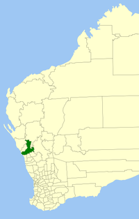
Cité de Greater Geraldton
- Cité de Greater Geraldton
-
28° 46′ 00″ S 114° 36′ 00″ E / -28.7667, 114.6
La Cité de 'Greater Geraldton (City of Greater Geraldton en anglais) est une zone d'administration locale sur la côte est de l'Australie-Occidentale en Australie à environ 424 kilomètres au nord de Perth, la capitale de l'État.
Elle résulte de la fusion du "comté de Greenough" et de la "cité de Geraldton" en 2007, et de la "comte de Mullewa" en 2011.
La zone est divisée en un certain nombre de localités:
- Cape Burney
- Drummond Cove
- Eradu
- Greenough
- Kojarena
- Minnenooka
- Moonyoonooka
- Mullewa
- Pindar
- Tardun
- Tenindewa
- Walkaway
- Wicherina
auxquelles il faut ajouter la ville de Geraldton divisée en quartiers:
La zone a 14 conseillers et est découpée en 7 circonscriptions qui élisent chacune deux conseillers:
- Champion Bay Ward
- Chapman Ward
- Port Ward
- Tarcoola Ward
- Willcock Ward
- Hills Ward
- Mullewa Ward
Liens externes
|
|
| Quartiers |
Beachlands · Beresford · Bluff Point · Cape Burney · Deepdale · Drummond Cove · Geraldton · Glenfield · Karloo · Mahomets Flats · Meru · Moresby · Mount Tarcoola · Narngulu · Rangeway · Rudds Gully · Spalding · Strathalbyn · Sunset Beach · Tarcoola Beach · Utakarra · Waggrakine · Wandina · Webberton · West End · Wonthella · Woorree |
 |
| Régional |
Eradu · Greenough · Kojarena · Minnenooka · Moonyoonooka · Nabawa · Nanson · Oakajee · Walkaway · Wicherina · Yuna |
 Australie Australie |
Catégories : - Zone d'administration locale du Mid West
- Fondation en 2008
Wikimedia Foundation.
2010.
Contenu soumis à la licence CC-BY-SA. Source : Article Cité de Greater Geraldton de Wikipédia en français (auteurs)
Regardez d'autres dictionnaires:
Geraldton — La cathédrale St Francois Xavier à Geraldton Administration … Wikipédia en Français
Karloo (Australie-Occidentale) — Karloo Administration Pays Australie … Wikipédia en Français
Beachlands (Australie-Occidentale) — Beachlands Administration Pays Australie … Wikipédia en Français
Mahomets Flats (Australie-Occidentale) — Mahomets Flats Administration Pays Australie … Wikipédia en Français
Signals intelligence operational platforms by nation — This article is a subset article under the main article Signals intelligence, which addresses the unifying conceptual and technical factors and common technologies in this intelligence discipline. This article deals with current signals… … Wikipedia
Petroleum in Western Australia — The Western Australian petroleum industry is the largest contributor to Australia s production of most petroleum products. [citeweb|url=http://www.appea.com.au/index.php?option=com content task=blogsection id=7 Itemid=32|title=2007 Production… … Wikipedia
Noongar — The Noongar (alternate spellings: Nyungar/Nyoongar/Nyoongah/Nyungah/Nyugah), [ [http://www.samuseum.sa.gov.au/tindale/HDMS/tindaletribes/wudjari.htm Norman Barnett Tindale] South Australia Museum. Retrieved 20 September 2006. ] are an indigenous… … Wikipedia
National Broadband Network — The National Broadband Network (NBN) is a national wholesale only, open access data network under development in Australia. Up to one gigabit per second connections are sold to retail service providers (RSP), who then sell Internet access and… … Wikipedia
Geography of Western Australia — Western Australia occupies nearly one third of the Australian continent.Due to the size and the isolation of the state, considerable emphasis has been made of these features; it is the second largest administrative territory in the world, after… … Wikipedia
Australia–New Zealand relations — The relationship between Australia and New Zealand is somewhat similar to that of other neighbouring countries with a shared British colonial heritage, such as Canada and the United States. Some have defined the relationship as less one of… … Wikipedia

 Australie

