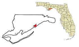
Carrabelle
- Carrabelle
-
Wikimedia Foundation.
2010.
Contenu soumis à la licence CC-BY-SA. Source : Article Carrabelle de Wikipédia en français (auteurs)
Regardez d'autres dictionnaires:
Carrabelle — Carrabelle, FL U.S. city in Florida Population (2000): 1303 Housing Units (2000): 790 Land area (2000): 3.731466 sq. miles (9.664451 sq. km) Water area (2000): 1.077901 sq. miles (2.791750 sq. km) Total area (2000): 4.809367 sq. miles (12.456201… … StarDict's U.S. Gazetteer Places
Carrabelle, FL — U.S. city in Florida Population (2000): 1303 Housing Units (2000): 790 Land area (2000): 3.731466 sq. miles (9.664451 sq. km) Water area (2000): 1.077901 sq. miles (2.791750 sq. km) Total area (2000): 4.809367 sq. miles (12.456201 sq. km) FIPS… … StarDict's U.S. Gazetteer Places
Carrabelle — Original name in latin Carrabelle Name in other language State code US Continent/City America/New York longitude 29.85326 latitude 84.66435 altitude 16 Population 2778 Date 2011 05 14 … Cities with a population over 1000 database
Carrabelle, Florida — Infobox Settlement official name = Carrabelle, Florida other name = native name = nickname = settlement type = City motto = imagesize = image caption = flag size = image seal size = image shield = shield size = image blank emblem = blank emblem… … Wikipedia
Carrabelle, Tallahassee and Georgia Railroad — The Carrabelle, Tallahassee and Gulf Railroad was a short railroad running in north Florida and southern Georgia. History The Carrabelle, Tallahassee and Gulf Railroad was incorporated on January 5, 1891. It was projected along a route extending… … Wikipedia
32322 — Carrabelle, Fl (Miscellaneous » ZIP Codes) … Abbreviations dictionary
Florida State Road 10 (pre-1945) — SR 10 was defined by number in 1923 state law, chapter 9311, approved June 8, 1923: * Extending from the Georgia State line near Beechton to East Point, via Tallahassee, Crawfordville, Blockers Ferry and Carrabelle.SR 10 was extended by number in … Wikipedia
Crooked River Light — Location near Carrabelle, Florida Coordinates … Wikipedia
Dog Island (Florida) — Coordinates: 29°48′N 84°37′W / 29.80°N 84.61°W / 29.80; 84.61 … Wikipedia
National Register of Historic Places listings in Franklin County, Florida — Location of Franklin County in Florida This is a list of the National Register of Historic Places listings in Franklin County, Florida. This is intended to be a complete list of the properties and districts on the National Register of Historic… … Wikipedia
 États-Unis
 Floride