Cape Woolamai
Contenu soumis à la licence CC-BY-SA. Source : Article Cape Woolamai de Wikipédia en français (auteurs)
Regardez d'autres dictionnaires:
Cape Woolamai, Victoria — Infobox Australian Place type = suburb name = Cape Woolamai state = vic caption = A map of Phillip Island with Cape Woolamai shown lga = Bass Coast Shire postcode = 3925 pop = 1234 (2006)Census 2006 AUS | id = SSC25305 | name = Cape Woolamai… … Wikipedia
List of localities in Victoria (Australia) — Map of Local Government Areas in Victoria This is a list of locality names and populated place names in the state of Victoria, Australia, outside the Melbourne metropolitan area. It is organised by region from the south west of the state to the… … Wikipedia
Contenu:Australie — Projet:Australie/Liste des articles Liste mise à jour régulièrement par MyBot (d · c · b) à partir des articles liés au bandeau {{Portail Australie}} Modifications récentes des articles ayant le bandeau de ce portail… … Wikipédia en Français
Cowes, Victoria — Cowes Victoria Golden Cypress trees on Thompson Avenue … Wikipedia
Corinella, Victoria — Corinella Victoria Aerial view of Corinella … Wikipedia
Outtrim, Victoria — Outtrim Victoria … Wikipedia
Phillip Island — Küste von Phillip Island Gewässer Bass Straße Geographische Lage … Deutsch Wikipedia
Bass Coast Shire — Infobox Australian Place | type = lga name = Bass Coast Shire state = vic caption = Location in Victoria pop = 26,548 (2006 Census) area = 859 est = 1994 seat = mayor = Neville Goodwin region = url = [http://www.basscoast.vic.gov.au www.basscoast … Wikipedia
Cliffy Island Lighthouse — Cliffy Island Lighthouse, 1917 Location Bass Strait, 17 nmi S of Port Albert, Victoria, Australia Coordinates … Wikipedia
Citadel Island — Lighthouse Location Bass Strait, 13 km SW of Tidal River, Wilsons Promontory, Australia Coordinates 39°06′54″S 146°14′13″E / … Wikipedia
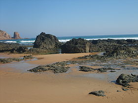 La plage et ses rochers
 Australie

