Phillip Island
- Phillip Island
-
38° 28′ 38″ S 145° 15′ 14″ E / -38.4772, 145.254

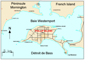
Carte de la baie Westernport et Phillip Island
Phillip Island (7 071 habitants) est une île située à l'entrée de la Baie de Western Port, au sud de Melbourne, dans l'État de Victoria en Australie.
L'île doit son nom au gouverneur Arthur Phillip un ancien gouverneur de la Nouvelle-Galles-du-Sud.
L'île a une superficie d'environ 100 km² avec une longueur de 26 km sur une largeur maximale de 9 km. Elle a 97 km de côtes. un pont de 640 mètres la relie au continent près de la ville de San Remo.
L'ile est utilisée pour l'élevage du bétail (ovin et bovin) sur 60 % de sa surface. Elle attire aussi beaucoup de touristes (3,5 millions par an) à cause de la présence de manchots pygmées qui rentrent par milliers le soir sur l'île et de la plus grande colonie australienne de lions de mer. On y pratique aussi le surf ou la pêche au gros.
Voir aussi
Catégories :
- Île du détroit de Bass
- Île du Victoria
Wikimedia Foundation.
2010.
Contenu soumis à la licence CC-BY-SA. Source : Article Phillip Island de Wikipédia en français (auteurs)
Regardez d'autres dictionnaires:
Phillip Island — Küste von Phillip Island Gewässer Bass Straße Geographische Lage … Deutsch Wikipedia
Phillip Island — Saltar a navegación, búsqueda Playa en Phillip Island. Phillip Island es una isla australiana localizada a 140 km de Melbourne (Victoria). Llamada así por el primer gobernador de Nueva Gales del Sur, Arthur Phillip, Phillip Island forma un… … Wikipedia Español
Phillip Island — may refer to:* Phillip Island (Victoria) ** Phillip Island Grand Prix Circuit **Phillip Island Nature Park * Phillip Island (Norfolk Island) … Wikipedia
Phillip Island — /fɪləp ˈaɪlənd/ (say filuhp uyluhnd) noun 1. an island lying across the entrance to Westernport in southern Victoria; tourist resort. 100 km2. 2. a small island in the Pacific near Norfolk Island. 3. a small island off the north eastern shore of… …
Phillip Island — Original name in latin Phillip Island Name in other language State code AU Continent/City Australia/Melbourne longitude 38.48349 latitude 145.23102 altitude 48 Population 7071 Date 2011 06 04 … Cities with a population over 1000 database
Phillip Island (Victoria) — Phillip Island is located about 140km away from Melbourne.Named after Governor Arthur Phillip, Phillip Island in Victoria, Australia, forms a natural breakwater for the shallow waters of Western Port Bay. The island area is approximately 10,000… … Wikipedia
Phillip Island (Norfolk Island) — Phillip Island is an uninhabited island located at coord|29|07|S|167|57|E|, 6 km south of Norfolk Island in the Southwest Pacific, and part of the Norfolk Island group. It was named in 1788 by Lieutenant Philip Gidley King for Arthur Phillip, the … Wikipedia
Phillip Island Circuit — Adresse: Phillip Island Grand Prix Circuit RMB 500GP COWES VICTORIA 3922 … Deutsch Wikipedia
Phillip Island (Norfolk) — Phillip Island Géographie Pays … Wikipédia en Français
Phillip Island Nature Park — (PINP) is a conservation park located on Phillip Island, Victoria, Australia. Created in 1996, the park is owned by the Victorian State Government, however it is a self funding commercial attraction for the purpose of animal conservation and… … Wikipedia

