Bridgend (county borough)
- Bridgend (county borough)
-
County borough de Bridgend
(sir Pen-y-bont ar Ogwr) |
 |
|
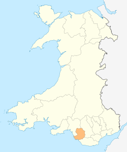
Localisation du comté au Pays de Galles
|
| Administration |
| Pays |
 Royaume-Uni Royaume-Uni |
| Type |
County borough |
| Autres villes |
Bridgend |
| Date de création |
1996 |
| ISO 3166-2 |
GB-BGE |
| Géographie |
| Superficie |
246 km2 |
| Population |
| Population |
133 900 hab. (2007) |
| Densité |
544,3 hab./km2 |
Bridgend est un comté (County Borough en anglais) située dans le sud du pays de Galles. Son centre administratif se trouve dans la ville de Bridgend.
Lien externe
Site officiel
Wikimedia Foundation.
2010.
Contenu soumis à la licence CC-BY-SA. Source : Article Bridgend (county borough) de Wikipédia en français (auteurs)
Regardez d'autres dictionnaires:
Bridgend County Borough — Bwrdeisdref Sirol Pen y bont ar Ogwr Geography Area Total % Water Ranked 17th 246 km² … Wikipedia
Bridgend (county borough) — Bridgend (Welsh: Pen y bont ar Ogwr ) is a county borough in Glamorgan, southern Wales. The county borough has a total population of 130,000 people, and contains the settlements of Bridgend, after which it is named, Maesteg, and the seaside town… … Wikipedia
Bridgend county borough — Admin ASC 2 Code Orig. name Bridgend county borough Country and Admin Code GB.WLS.X3 GB … World countries Adminstrative division ASC I-II
Bridgend County Borough Council — ( cy. Cyngor Bwrdeistref Sirol Pen y bont ar Ogwr) is the governing body for Bridgend County Borough, one of the Principal Areas of Wales.Electoral divisionsThe county borough is divided into 39 electoral wards. Some of these wards are… … Wikipedia
List of places in Bridgend county borough — This is a list of places in the Bridgend county borough, south Wales.Administrative divisionsElectoral wardsThis is a list of electoral wards in Bridgend county borough:CommunitiesThis is a list of communities:Notable PlacesPrincipal towns and… … Wikipedia
County borough — Category Borough Location England and Wales and Ireland Found in Counties Created by Local Government Act 1888 Local Government (Ireland) Act 1898 … Wikipedia
Caerphilly (county borough) — County borough de Caerphilly (Sir Caerffili) Localisation du comté au Pays de Galles Administration Pays … Wikipédia en Français
Conwy (county borough) — County borough de Conwy (Sir Conwy) Localisation du comté au Pays de Galles Administration Pays … Wikipédia en Français
Conwy County Borough — Bwrdeistref Sirol Conwy County Borough Geography Area Total % Water Ranked 6th 1,130 km² ? % … Wikipedia
Caerphilly County Borough — Coordinates: 51°39′22″N 3°10′59″W / 51.656°N 3.183°W / 51.656; 3.183 … Wikipedia
