Boonah
Contenu soumis à la licence CC-BY-SA. Source : Article Boonah de Wikipédia en français (auteurs)
Regardez d'autres dictionnaires:
Boonah, Queensland — Boonah redirects here. For the 1918 Spanish influenza infected ship off Fremantle, see Boonah crisis. Boonah Queensland Main street of Boonah … Wikipedia
Boonah Motel — (Boonah,Австралия) Категория отеля: 3,5 звезд Адрес: 1 Mount Carmel Road, 4310 Boonah … Каталог отелей
Boonah crisis — The HMAT Boonah was the last Australian troop ship to leave Fremantle, Western Australia bound for the Middle East in October 1918, near the end of the World War I. Carrying about 1200 AIF soldiers, [cite web |… … Wikipedia
Boonah — /ˈbunə/ (say boohnuh) noun a town and shire in south eastern Qld, south west of Brisbane …
Shire of Boonah — Infobox Australian Place | type = lga name = Shire of Boonah state = qld imagesize= 135px caption = Location within Queensland area = 1921.6 est = 1880 seat = Boonah pop = 8,770 pop footnotes = (2006 census) [Census 2006 AUS | id = LGA30800 |… … Wikipedia
Notozomus boonah — Notozomus boonah … Wikipédia en Français
Comté de Boonah — 27°59′50.41″S 152°40′55.98″E / 27.9973361, 152.6822167 … Wikipédia en Français
Dugandan railway line — Legend … Wikipedia
Cunningham Highway — Cunningham Highway … Wikipedia
West Pymble, New South Wales — Infobox Australian Place | type = suburb name = West Pymble city = Sydney state = nsw caption = Ku ring gai area lga = Ku ring gai Council postcode = 2073 est = pop = 4,826 (2001 census) area = 3.58 propval =… … Wikipedia
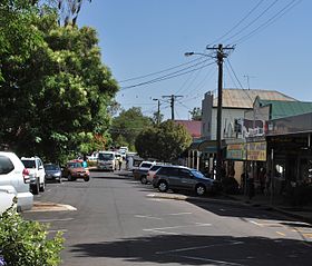 La grand'ue de Boonah
 Australie
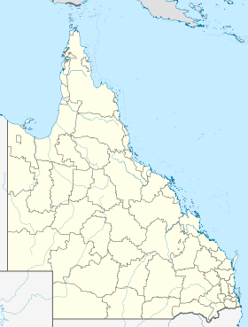
 Boonah


