Dépression du Bodélé
- Dépression du Bodélé
-
17° N 18° E / 17, 18
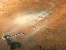
Image satellite d'
une tempête de sable partie de la dépression du Bodélé située en haut à droite ;
le lac Tchad est visible en bas à droite.
La dépression du Bodélé est une dépression géographique située dans le centre sud du Sahara, dans le nord du Tchad. Elle est entourée au nord par le Tibesti et au sud-ouest par le bassin du lac Tchad. La dépression aurait accueilli un lac, aujourd'hui asséché, lors de la période plus humide que le Sahara ait connu au cours de la Préhistoire.
Wikimedia Foundation.
2010.
Contenu soumis à la licence CC-BY-SA. Source : Article Dépression du Bodélé de Wikipédia en français (auteurs)
Regardez d'autres dictionnaires:
Bodélé Depression — The Bodélé Depression (also Bodele), located at the southern edge of the Sahara Desert in north central Africa, is the lowest point in Chad, [http://earthobservatory.nasa.gov/NaturalHazards/natural hazards v2.php3?img id=13964 Dust Storm in the… … Wikipedia
Bodélé-Depression — Staubsturm in der Bodélé Depression am 18. Februar 2004 Die Bodélé Depression ist eine Senke im Zentrum des Tschad am südlichen Rand der Sahara. Im Norden und Nordosten wird sie durch das Tibesti Gebirge bzw. das Windkorrasionsgebiet von Borkou,… … Deutsch Wikipedia
Géographie du Tchad — 15° N 19° E / 15, 19 … Wikipédia en Français
Dust storm — For the fictional character, see Dust Storm (Transformers). For other uses, see Sandstorm (disambiguation). Part of the Nature series on Weather Calendar seasons … Wikipedia
Diatomaceous earth — A sample of diatomaceous earth Diatomaceous earth ( / … Wikipedia
Tschadbecken — Staubsturm über dem Tschadbecken am 18. November 2004 Quelle: NASA Das Schari Logone Fl … Deutsch Wikipedia
Chad Basin — The Chad Basin, also known as the Lake Chad Basin, is a large lowland area in north central Africa. In all directions from the center of this area the elevation changes are gentle. The Chad Basin is an endorheic (closed) basin its water does not… … Wikipedia
Mega-Tschad — Maximale Ausdehnung des Mega Tschad im Holozän Als Mega Tschad (auch Paleo Tschad) bezeichnet man einen Paleo See im Tschadbecken in Zentralafrika, der zuletzt im Mesolithikum einen Mega See formte. Seinen tiefsten Punkt hatte er in der heutigen… … Deutsch Wikipedia
Geography of Chad — Map of Chad Satellite image of Chad … Wikipedia
Libysche Wüste — Die Libysche Wüste, arabisch الصحراء الليبية, DMG aṣ ṣaḥrāʾ al lībiya (die Schreibweise der Eigennamen folgt meist der international üblichen englischen Transkription des Ägyptisch Arabischen) wird in Ägypten wegen der historischen… … Deutsch Wikipedia

