Beňatina

Beňatina
Beňatina
(Village)
Administration
Pays Drapeau de Slovaquie Slovaquie
Région Région de Košice
District District de Sobrance
Code postal 072 64
Plaque minéralogique SO
Starosta (maire) Štefan Minčák ( Indépendant )

Mandat: 2013

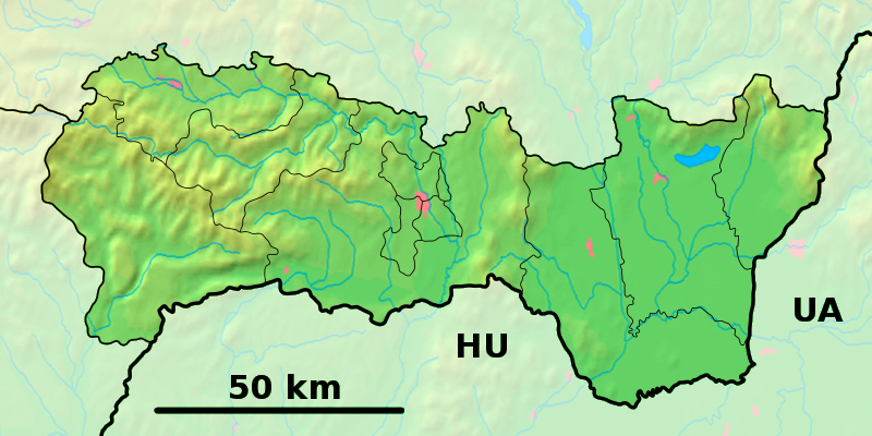
Démographie
Population 225 hab. (31.12.2007)
Densité 12,1 hab./km2
Géographie
Coordonnées 48° 48′ 30″ Nord
       22° 19′ 20″ Est
/ 48.808333, 22.322222
Altitude 406 m
Superficie 1 864 ha = 18,640 km²
Localisation en Slovaquie
Voir la carte physique
Localisation de la ville
Beňatina
Voir la carte administrative
Localisation de la ville
Beňatina
Localisation dans la région de Košice
Voir la carte physique
Localisation de la ville
Beňatina
Voir la carte administrative
Localisation de la ville
Beňatina
Internet
Site de la commune http://www.benatina.ocu.sk
Sources
Resultat des élections
http://www.e-obce.sk [1]
http://www.statistics.sk [2]
http://www.slovakregion.sk/ [3]

Beňatina (hongrois : Vadászfalva)[4] est un village de Slovaquie situé dans la région de Košice.

Histoire

Première mention écrite du village en 1333[2].

Politique

Liste des Starostas (maires)[5]
Nom Parti politique Date de l'élection Fin du mandat
Andrej Petrúň ĽS-HZDS,SNS,KDH,SDKÚ-DS 02.12.2006 Déc. 2010

Notes et références

  1. (sk) e-obce.sk. Consulté le 28 janvier 2010
  2. a et b (sk) (en) Mestská a obecná štatistika SR. Consulté le 28 janvier 2010
  3. (sk) Slovak region. Consulté le 28 janvier 2010]
  4. (sk) (en) Názvy obcí Slovenskej republiky (Vývin v rokoch 1773 – 1997). Consulté le 28 janvier 2010
  5. (sk) Zoznam zvolených starostov obcí, primátorov miest a starostov mestských častí. Consulté le 29 janvier 2010

Wikimedia Foundation. 2010.

Contenu soumis à la licence CC-BY-SA. Source : Article Beňatina de Wikipédia en français (auteurs)

Игры ⚽ Нужна курсовая?

Regardez d'autres dictionnaires:

  • Beňatina — is a village and municipality in the Sobrance District in the Košice Region of east Slovakia.HistoryIn historical records the village was first mentioned in 1333.GeographyThe village lies at an altitude of 410 metres and covers an area of 18.64… …   Wikipedia

  • Liste der Städte und Gemeinden in der Slowakei/A-G — Übersicht A bis G Teil 1 A bis G Teil 2 H bis Ľ Teil 3 M bis R Teil 4 S bis Ž Übersicht A B C Č D Ď E F G A …   Deutsch Wikipedia

  • Liste der Städte und Gemeinden in der Slowakei Teil 1 — Übersicht A bis G Teil 1 A bis G Teil 2 H bis Ľ Teil 3 M bis R Teil 4 S bis Ž Übersicht A B C Č D Ď E F G A …   Deutsch Wikipedia

  • District de Sobrance — Sobrance Informations Pays …   Wikipédia en Français

  • Košice Region — Geobox | Region name = Košice other name = category = Region image caption = image caption = symbol = symbol type = Coat of arms etymology = official name = motto = nickname = country = Slovakia country state = region = district = commune =… …   Wikipedia

  • Sobrance District — Infobox Slovak district subject name = Sobrance District region district slovak region = Košice Region population = 23,776 (2001) prefix = ? area = 538 car plate = SO image location = Okres sobrance.png Sobrance District ( okres Sobrance ) is a… …   Wikipedia

  • Ostrov, Sobrance District — Location of Sobrance District in the Košice Region Ostrov is a village and municipality in the Sobrance District in the Košice Region of eastern Slovakia …   Wikipedia

  • List of municipalities and towns in Slovakia — Slovakia This is a comprehensive list of municipalities and towns in Slovakia. For lists of towns and municipalities sorted by Regions see the individual articles on Regions. For an outdated list of towns only in Slovakia see also List of towns… …   Wikipedia

  • Choňkovce — Location of Sobrance District in the Košice Region Choňkovce is a village and municipality in the Sobrance District in the Košice Region of east Slovakia. Contents …   Wikipedia

  • Nižná Rybnica — Location of Sobrance District in the Košice Region Nižná Rybnica is a small village and municipality in the Sobrance District in the Košice Region of east Slovakia. Contents …   Wikipedia

Share the article and excerpts

Direct link
Do a right-click on the link above
and select “Copy Link”