Tehsil d'Abbottabad
- Tehsil d'Abbottabad
-
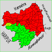
Le Tehsil d'Abbottabad est l'un des deux Tehsil (avec celui d'Havelian) du District d'Abbottabad au Pakistan.
Les Union Councils
Le Tehsil d'Abbottabad est subdivisé en 35 Union Councils :
Union Council de Nathiagali

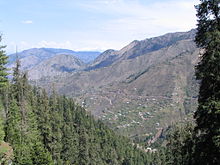
Vue de l'
Union Council de Nathiagali.
Cette section est vide,
insuffisamment détaillée ou incomplète.
Votre aide est la bienvenue !
Liens externes
Wikimedia Foundation.
2010.
Contenu soumis à la licence CC-BY-SA. Source : Article Tehsil d'Abbottabad de Wikipédia en français (auteurs)
Regardez d'autres dictionnaires:
Abbottabad District — Abottabad District District Map of Hazara, Pakistan with Abbottabad District highlighted Country … Wikipedia
Abbottabad Tehsil — Infobox Tehsil Pakistan tehsil caption = Map showing the administrative subdivisions of Abbottabad District, Abbottabad Tehsil is highlighted in red. official name= Abbottabad province= North West Frontier Province district= Abbottabad area total … Wikipedia
Tehsil d'Havelian — 33° 56′ 00″ N 73° 07′ 00″ E / 33.9333, 73.1167 … Wikipédia en Français
Abbottabad Central — Union Councils name = Abbottabad Central caption = Abbottabad Central province = NWFP district = Abbottabad tehsil = Abbottabad nazim = Shoukat Ali naib nazim = Jabar Hussai Siddiqui population = 27,915 coordinates = Abbottabad Central is one of… … Wikipedia
Havelian Tehsil — Infobox Tehsil Pakistan tehsil caption = Map showing the administrative subdivisions of Abbottabad District, Havelian Tehsil is highlighted in green. official name= Havelian province= North West Frontier Province district= Abbottabad area total… … Wikipedia
District d'Abbottabad — 34°00′N 73°00′E / 34, 73 Dist … Wikipédia en Français
District Abbottabad — District d Abbottabad Abbottabad (Urdu : le ایبٹآباد) est un district dans la province du nord ouest de frontière du Pakistan, la ville principale est la ville d Abbottabad. Subdivisions de l Abbottabad Abbottbad district Il a deux tehsils… … Wikipédia en Français
Haripur District — Infobox Pakistan district district = Haripur District area = 1,725 km² population = 803,000 pop year = 2005 density = 466 per km² caption = Location of Haripur District (highlighted in red) within the North West Frontier Province. region = North… … Wikipedia
Circle Bakote — is a cluster of Union Councils in the eastern part of Abbottabad District in the North West Frontier Province of Pakistan. Circle Bakote is located on the upper and west bank of the Jhelum River at Kohalla Bridge. The region is somewhere between… … Wikipedia
Mughal (tribe) — Mughal Total population 2,666,000[1] Regions with significant populations • India • … Wikipedia


