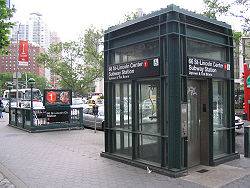
66th Street
Contenu soumis à la licence CC-BY-SA. Source : Article 66th Street de Wikipédia en français (auteurs)
Regardez d'autres dictionnaires:
66th Street (Manhattan) — 66th Street is a crosstown street in the New York City borough of Manhattan with portions on the Upper East Side and Upper West Side connected across Central Park via the 65th Street Transverse. West 66th Street is the location of the historical… … Wikipedia
66th Street–Lincoln Center (IRT Broadway–Seventh Avenue Line) — Infobox NYCS name = 66th Street–Lincoln Center accessible = yes bg color = #E20F00 line = IRT Broadway–Seventh Avenue Line service = Broadway Seventh local platforms = 2 side platforms tracks = 4 passengers = 7.271 million pass year = 2006 pass… … Wikipedia
59th Street — – Columbus Circle … Wikipedia
72nd Street (IRT Broadway — 72nd Street … Wikipedia
59th Street–Columbus Circle (New York City Subway) — Infobox NYCS name=59th Street–Columbus Circle bg color=black service=Columbus Circle borough=Manhattan passengers=19.355 million pass percent=4 pass year=200659th Street–Columbus Circle is a New York City Subway station complex shared by the IRT… … Wikipedia
72nd Street (IRT Broadway–Seventh Avenue Line) — Infobox NYCS name = 72nd Street accessible = yes bg color = #E20F00 line = IRT Broadway–Seventh Avenue Line service = Broadway Seventh platforms = 2 island platforms tracks = 4 passengers = 11.012 million pass year = 2006 pass percent = 2 borough … Wikipedia
Christopher Street (Manhattan) — For other uses, see Christopher Street (disambiguation). Street sign … Wikipedia
Mott Street (Manhattan) — Coordinates: 40°43′11″N 73°59′47″W / 40.7196°N 73.9963°W / 40.7196; 73.9963 … Wikipedia
52nd Street (Manhattan) — 52nd Street redirects here. For other uses, see 52nd Street (disambiguation). Coordinates: 40°45′25″N 73°58′11″W / 40.757076°N 73.969857°E / 40.757076; … Wikipedia
Mulberry Street (Manhattan) — Mulberry Street (c.1900) Mulberry Street is a principal thoroughfare in Manhattan, New York. The street was listed on maps of the area since at least 1755. The Bend in Mulberry in which the street changes direction from southwest to northeast to… … Wikipedia

