Baker City
- Baker City
-
44° 46′ 26″ N 117° 49′ 48″ W / 44.773889, -117.830000
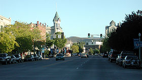
Baker City est une ville américaine, siège du comté de Baker dans l'Oregon, dont la population est estimée en 2006 à 10.035 habitants. Le nom de la ville provient du nom du comté.
Histoire
Bien que le premier bureau de poste fut établi en 1866, la ville ne fut incorporée qu'en 1874. La ville fut baptisée Baker City du nom du comté qui provient lui-même du sénateur américain Edward Dickinson Baker. En 1911, la ville fut rebaptisée Baker jusqu'aux années 1980 où elle retrouva son d'origine Baker City.
Géographie
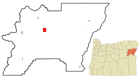
La ville se situe à l'est de l'Oregon, dans une vallée entre les montagnes Wallowa à l'est et la cordillère Elkhorn, une partie des montagnes Bleues, à l'ouest. La rivière Powder traverse la ville.
Baker City possède un aéroport (Baker City Municipal Airport, code AITA : BKE).
Jumelage
Liens internes
Lien externe
v · sièges de comtés de l’État de l’ Oregon  |
|
|
Wikimedia Foundation.
2010.
Contenu soumis à la licence CC-BY-SA. Source : Article Baker City de Wikipédia en français (auteurs)
Regardez d'autres dictionnaires:
Baker City — Baker City, OR U.S. city in Oregon Population (2000): 9860 Housing Units (2000): 4435 Land area (2000): 6.907312 sq. miles (17.889854 sq. km) Water area (2000): 0.000000 sq. miles (0.000000 sq. km) Total area (2000): 6.907312 sq. miles (17.889854 … StarDict's U.S. Gazetteer Places
Baker City, OR — U.S. city in Oregon Population (2000): 9860 Housing Units (2000): 4435 Land area (2000): 6.907312 sq. miles (17.889854 sq. km) Water area (2000): 0.000000 sq. miles (0.000000 sq. km) Total area (2000): 6.907312 sq. miles (17.889854 sq. km) FIPS… … StarDict's U.S. Gazetteer Places
Baker City — (spr. bēker ßitti), Hauptstadt der Grafschaft Baker im O. des nordamerikan. Staates Oregon, am Powder River, Bahnknotenpunkt und Produktenmarkt, mit (1900) 6663 Einw … Meyers Großes Konversations-Lexikon
Baker City — ▪ Oregon, United States city, seat (1868) of Baker county, northeastern Oregon, U.S. It is situated along the Powder River, in Baker Valley, between the Blue Mountains (west) and the Wallowa Mountains (east). Lying on the old Oregon Trail… … Universalium
Baker City — Original name in latin Baker City Name in other language Behjker Siti, Бэйкер Сити State code US Continent/City America/Los Angeles longitude 44.77487 latitude 117.83438 altitude 1053 Population 9828 Date 2012 02 20 … Cities with a population over 1000 database
Baker City, Oregon — City Main Street … Wikipedia
Baker City Municipal Airport — Baker City Baker City Pays États Unis État … Wikipédia en Français
Baker High School (Baker City, Oregon) — Baker High School is a public high school in Baker City, Oregon, United States. It is part of the Baker School District 5J. History*1989 The school caught on fire and was mostly destroyed. No one was hurt as all students, teachers, and staff were … Wikipedia
Baker City Forest Reserve — was established by the General Land Office in Oregon on February 5, 1904 with 52,480 acres. In 1905 all federal forests were transferred to the U.S. Forest Service. On March 15, 1906 portions of Baker City were combined with Blue Mountains Forest … Wikipedia
Baker City, Diocese of — • Comprises Wasco, Klamath, Lake, Sherman, Gilliam, Wheeler, Morrow, Grant, Union, Crook, Umatilla, Wallowa, Baker, Harney, and Malheur counties in the State of Oregon, U.S.A Catholic Encyclopedia. Kevin Knight. 2006 … Catholic encyclopedia

 États-Unis
 Oregon
 Zeya (Russie)


